
Economic Geology News
ADAKITES -- THE PHENOMENAL TRIO OF ROBERT R. LOUCKS' PUBLICATIONS - A SYNOPTIC VIEW (April 1st, 2024)
.
Adakites are volcanic or subvolcanic igneous rocks that were first described by Defant & Drummond (1990) from Adak Island in the Arctic Pacific Ocean. At that time the authors presumed that the rocks owe their specific sodic and felsic chemistry to melting of hot slabs younger than 25 Ma. Soon, many more occurrences of these rocks were discovered globally, and the observation was made that adakites are frequently associated with copper and gold deposits. This inspired assumptions of genetic relations, but the precise cause remained speculative.
Adakites are volcanic rocks in modern island arcs, mostly dacitic, but compositions range from hornblende-andesite to dacite and rhyolite. Aadakites appear mainly restricted to subduction settings that show unusually high heat-flow, such as subduction of young oceanic crust, subduction initiation, ridge subduction, flat subduction (Martin et al. 2005); or slab breaks etc. Adakite is a sub-type of siliceous calc-alkalic igneous rock formed from melts that are chemically distinguishable from ordinary andesitic-dacitic-rhyolitic melts (58-70 wt% SiO2) by relatively high Al2O3 >= 15 wt%, high Sr > 400 ppm, low Y < 18 ppm, Sr/Y >= 30 and low contents of heavy lanthanides (Yb <= 1.9 ppm) (Defant & Drummond 1990).
A trio of recent publications provides hard data and enables surprising petrogenetic, geological and metallogenic interpretations. The type locality is Adak Island in the central Aleutians, situated in a strongly compressive segment of the island arc, where magmas undergo magmatic differentiation to andesitic and more siliceous compositions at Moho-vicinity pressures, according to evidence from cumulate gabbroic and uppermost mantle peridotite xenoliths in adakitic lavas. There is no evidence in adakites at Adak for melting of subducted oceanic crust or pelagic sediments (Loucks 2021).
The earliest of the above mentioned trio of papers established the role of tectonic stress by withholding or facilitating melt flow from the subduction zone below a volcanic arc upwards into the continental crust und to the level of ore formation (Loucks 2021). Various physical and petrological boundary conditions are patiently deduced by this author, e.g. why buoyant magma is either dammed up at the Moho forming horizontal sheets and chambers, or why it breaks through to resumed ascent through the crust. The author provides a complete and well-argued model of the subduction-related origin of adakite melts and their role in ore deposit formation:
At a metallogenic subduction factory underneath an active continental margin or an island arc, the slab is devolatized by low T/high P metamorphism; metals and ligands are mobilized. The mafic crust along the slab top and seamounts is the main source of fluids released at fore-arc and subarc depths. Passing through mantle, they enrich, or 'metasomatize' it and induce partial melting. Thus the mantle becomes the source of hydrous, metalliferous basalts and fluids that rise toward the Moho (Mohorovicic discontinuity, the boundary between continental crust and mantle) were they may be stopped by a zone of compressive orogenic stresses, and while underplating, experience gabbroic to peridotitic cumulate formation on the chamber floor.
Within the Moho-level chamber, replenishing mantle melts mix with resident residual melts, and the hybrids inherit metals, Sr, H2O, Cl, CO2 and SO3 accumulated from prior replenishment-and-differentiation cycles, higher Sr/Y in melt, and exceptional contents of dissolved water in residual melts (10 to over 20 wt%). These accumulations endow the adakitic melts with ore-forming properties (Loucks 2021).
When the orogenic stress decreases, the buoyant overpressured hydrous adakitic melt penetrates the roof and flows upwards in supercritical fluid/melt columns towards the surface; during the trans-crustal ascent of the magmas hydrothermal fluid may exsolve and segregate, forming orogenic ore. Nearer to the surface, mineralizing systems such as porphyry, epithermal and iron oxide copper gold (IOCG) may form deposits. The paper by Loucks (2021) is enriched by numerous references to adakite-related or adakite-hosted ore deposits.

- FIGURE 1 Tectonomagmatic setting of the Aleutian island arc (Courtesy RR Loucks 2021). (a) In the eastern Aleutians, the plate convergence is nearly orthogonal to the trench, but westward along the Aleutians the convergence becomes increasingly oblique. Increasing tangential shear in the central and western Aleutians has caused the arc to break up into a lateral succession of block segments rotating clockwise (Geist et al. 1988). Locations of the calc-alkalic-adakitic Adak magmatic centre at the western end of the rotating Andreanof Block and of the tholeiitic Semisopochnoi magmatic centre at the eastern end of the rotating Rat Block are identified. Red triangles locate active volcanoes. Orange contours labelled "100 km" to "600 km" are depths to the top of the subducting slab, determined by local seismicity on the Wadati-Benioff zone at shallow depths <= 270 km and determined by teleseismic tomographic imaging in aseismic portions of the slab at greater depths (Boyd and Creager 1991). Seafloor magnetic anomalies indicate that the subducted oceanic crust and pelagic sediments under Adak are ~ 53 Myr old and hence too cold to melt at the slab-mantle interface. (b) All available published whole-rock analyses of Quaternary samples are shown on this plot of ppm Zr in compiled analyses of samples from the Adak and Semisopochnoi magmatic centres. In Aleutian extensional settings, the trend of Zr vs SiO2 rises steeply until zircon saturates at ~ 70 wt% SiO2. In the Adak suite and volcanoes in other compressive segments having parental basaltic melts nearly identical to Semisopochnoi, the Zr vs SiO2 trend is flatter. The composition of "average Cenozoic circum-Pacific adakite" is taken from the compilation by Drummond et al. (1996). ( c ) Contrasting trends of whole-rock Sr/Zr ratio in the compiled volcanic samples from Adak and Semisopochnoi. The Sr/Zr ratio shows divergent differentiation trends from initially similar mafic parent magmas, with a sub-horizontal trend in the compressive segments and a steep, steady decline in the extensional settings (Courtesy RR Loucks 2021).
.
The second of the adakite-trio extends the theme of petrogenesis and tectonic stress and develops a fertility criterion for porphyry copper rock (Loucks & Fiorentini 2023a). We learn, for example, that porphyry copper ore-forming magmas worldwide are chemically distinguished from ordinary arc granitoids by lower Zr and by higher Sr/Zr ratios at equivalent SiO2 contents. Low ppm Zr in zircon-saturated melts and high whole-rock Sr/Zr in granitoid samples retaining igneous plagioclase are useful discriminants of Cu-fertile intrusive complexes. Locations studied comprised Adak, El Teniente (Chile), Batu Hijau (Indonesia), and Chinkuashih (Taiwan). In non-compressive to weakly compressive stress settings, arc magmas follow a tholeiitic trend; in moderately compressive settings, a calc-alkalic trend dominates; in highly compressive, orogenically deforming arc segments, an adakitic differentiation trend is characteristic.
The third of the adakite-trio is an innovative presentation of how water determines the oxidation of melts and fluids in the subduction system (Loucks & Fiorentini 2023b). An oxydized redox state was known for many host and country rocks of porphyry copper mineralisation, but a variety of earlier assumptions did leave this conundrum partly unanswered (Pohl 2022a and b). Starting from chemical principles, and employing trace elements in zircon, the authors follow the path of water in the slab from before entering the subduction zone to the differentiation chamber at the Moho, and to magmatic-hydrothermal alteration in the deposit. They report as a rule, that higher hydration commonly, but not always, leads to increasing oxidation. Superhydrous melts exiting the near-Moho replenishment-and-differentiation chambers are commonly oxidized (Figure 2).

- FIGURE 2 Schematic sketch of adakite origin in the plate tectonic setting of convergent margin metallogeny, sketched by Pohl (2024) and inspired by Loucks' trio. Beneath the Moho at strongly compressive stresses underneath the volcanic arc, hydrous, metalliferous basalts and fluids pond, and while cooling, undergo differentiation to mafic cumulates versus andesitic and more siliceous adakitic melts. At waning orogenic pressure, the overpressured adakitic melt/fluids break through and rise towards the surface, in the style of a buoyant hydrous superpressured adakitic melt MASH (melting-assimilation-storage-homogenization) column. With waning pressure while rising, fluids segregate from melt. Compare this drawing with the one in the previous blog. Cite Figure 2 as authored by (Courtesy WL Pohl 2024) (downloadable from https://walterpohl.com/news.html).
.
The mafic crust along the slab top and seamounts are the main source of water released at fore-arc and subarc depths (Chesley et al. 2021; Holt & Condit 2021). Deeper down, the eclogitized slab breaks and founders downwards. Metalliferous supercritical fluids and melts may metasomatize ('fertilize') the mantle wedge or subcontinental lithospheric mantle (SCLM). Enriched, or 'metasomatized' mantle is the source of hydrous, metalliferous basalts and fluids that are mobilized by heat pulses and rise as supercritical fluid/melt columns toward the surface where they may feed ore-forming systems such as porphyry, epithermal and orogenic ore deposits. The hydrous nature of alteration and hydration zones and higher conductivity of mineralized bodies can be detected and imaged by modern geophysics such as magneto-tellurics.
The adakite-trio succeeds brilliantly to advance understanding of suprasubduction zone metallogeny. In the authors' process system, there is ample room for branching orogenic, IOCG, porphyry and epithermal ore deposits. Science and exploration must take note. For exploration guides, study the trio, please. All three are Open Access.
References
Chesley, C., Naif, S., Key, K. et al. Fluid-rich subducting topography generates anomalous forearc porosity. Nature 595, 255-260 (2021). https://doi.org/10.1038/s41586-021-03619-8
Defant, MJ & Drummond, MS (1990) Derivation of some modern arc magmas by melting of young subducted lithosphere. Nature 347 (6294) 662-665. Bibcode:1990Natur.347..662D. doi:10.1038/347662a0. S2CID 4267494.
Loucks, RR & Fiorentini, ML (2023b) Oxidation of magmas during gain and loss of H2O recorded by trace elements in zircon. Earth and Planetary Science Letters 622, 118377, ISSN 0012-821X. https://doi.org/10.1016/j.epsl.2023.118377. OPEN ACCESS
Loucks, RR & Fiorentini, ML (2023a) Early zircon saturation in adakitic magmatic differentiation series and low Zr content of porphyry copper magmas. Miner Deposita. https://doi.org/10.1007/s00126-023-01208-5 OPEN ACCESS
Loucks, RR (2021) Deep entrapment of buoyant magmas by orogenic tectonic stress: Its role in producing continental crust, adakites, and porphyry copper deposits. Earth-Science Reviews 220, 103744, ISSN 0012-8252. https://doi.org/10.1016/j.earscirev.2021.103744. OPEN ACCESS
Martin H, Smithies RH, Rapp R, et al. (2005) An overview of adakite, tonalite-trondhjemite-granodiorite (TTG), and sanukitoid: relationships and some implications for crustal evolution. Lithos 79 (1-2), 1-24. doi:10.1016/j.lithos.2004.04.048.
Pohl, WL (2022a) Metallogenic models as the key to successful exploration -- a review and trends. Mineral Economics (2022) : 36 pp. Springer. https://doi.org/10.1007/s13563-022-00325-3 OPEN ACCESS
Pohl, WL (2022b) Metallogenic models as the key to successful exploration -- a review and trends. Mineral Economics (2022) Springer. Supplementary Information: The online version contains supplementary material (Figures and Subtitles) available at https:// doi. org/ 10. 1007/ s13563- 022- 00325-3 OPEN ACCESS
back to top
Home
Orogenic Gold Deposits - Contradictory Genetic Hypotheses in Authoritative Papers (Feb 07, 2024) (UPDATE MARCH 1st, 2024)
.
You may have noticed in your work that genetic classification of some gold deposit variants is ambiguous. Deposit 'types' of gold, for example, in order of decreasing endowment and overall economic importance, comprise: Paleoplacer, orogenic, porphyry, epithermal, Carlin, geologically young placer, reduced intrusion related, oxidized intrusion related, volcanogenic massive sulfide (VMS), skarn, carbonate replacement, and iron oxide-copper-gold (IOCG) (Sillitoe 2020). Pohl (2020 and 2022) provides details, proposing a petrogenetic-geodynamic classification. In the last 12 months, several authoritative but in part each other contradicting sources appeared:
(1) The most recent paper is by Ian Groves et al. (2024), the proposer of the term 'Orogenic Gold Deposits' (OGD), who shift the source of the mineralizing fluids of OGD into the subduction related mantle. When the original proposal was made (Groves et al. 1998), the scene of possible source processes was sought in the crust, either crustal melting or metamorphism. Since then, the potential role of subcrustal heat pulses in metallogeny was increasingly recognized. In the standard operation mode of subduction, extreme heat flow events are not expected, but lithospheric delamination, slab break-offs, slab roll-back, slab tear, ridge subduction, plume impingement, and various other geodynamic perturbances may trigger upflow of hot asthenosphere. This boosts devolatilization of supercritical aqueous fluids or melts from the subducting slab, or from a previouly hydrated peridotitic mantle wedge. Partial melting produces basaltic melts that dam up at the Moho ('underplating') and undergo changes toward adakitic compositions. When orogenic stress ceases, the buoyant hydrous adakite melt perforates the roof and entrains metals and ligands into the deep or mesozonal crust where most orogenic gold deposits are formed; or up to the surface, where porphyry and epithermal deposits may originate (Loucks 2021).

- Figure 5 (POHL 2022) Schematic sketch of major plate tectonic settings of convergent margin metallogeny: Mid-oceanic Cu-Zn-Au-Ag mineralization (triangles) is being carried towards the metallogenic subduction factory underneath an active continental margin, where the slab is devolatized by low T/high P metamorphism; also, metals and ligands are mobilized. The mafic crust along the slab top and seamounts are the main source of fluids released at fore-arc, and melts at subarc depths. Deeper down, the eclogitized slab breaks and founders downwards. Metalliferous supercritical fluids and melts may metasomatize ('fertilize') the mantle wedge or subcontinental lithospheric mantle (SCLM). At the Moho (Mohorovicic discontinuity, the boundary between continental crust and mantle), basaltic melts assemble in a process called the Moho underplating system (red circles) and form mafic-ultramafic cumulates. Gradually by differentiation, the residual liquid acquires an adakitic character.
.
Enriched, or 'metasomatized' mantle is the source of hydrous, buoyant metalliferous basalts and fluids that rise toward the Moho, were they may be stopped by a zone of orogenically compressed rock, and while underplating, experience gabbroic to peridotitic cumulate formation on the chamber floor. In the Moho-level chamber, replenishing mantle melts mix with resident residual melts, and the hybrids inherit Sr, H2O, Cl, CO2 and SO3 accumulated from prior replenishment and differentiation cycles, high (adakitic) Sr/Y in melt, and exceptional contents of dissolved water in residual melts (10-20 wt%). These accumulations endow the adakitic melts with ore-forming properties (Loucks 2021). When the orogenic stressfield decreases, the buoyant overpressured residual adakitic melt will break the roof of the sill and flow upwards in supercritical fluid/melt columns, where it may feed ore-forming systems such as porphyry, epithermal and orogenic deposits. Improved strategies in the search for ore deposits emerge from understanding the igneous petrogenesis (Loucks & Fiorentini 2023 a and b; Loucks 2021: THE PHENOMENAL OPEN ACCESS TRIO OF LOUCK'S PUBLICATIONS).

- Figure 7 Hydrous magmas with initial 6-8 wt% H2O can be modeled using VolatileCalc (USGS 2002) to show how aqueous-carbonic fluids resembling those characterizing most orogenic gold deposits can be generated at mesozonal and hypozonal depths (courtesy by Jon Blundy). For example, felsic melts are modeled with initial compositions as shown (dots) and first reaching saturation at pressures of about 8 kb (8 wt% H2O) and 4 kb (6 wt% H2O). Fluids typical of orogenic gold (80-95 mol% H2O) may characterize these modeled magmatic-hydrothermal systems at depths of 7-19 km (or much more?) of gold porphyry and epithermal deposits. Courtesy Goldfarb & Pitcairn (2023).

.
I wonder if the diagram of Fig. 7 (Goldfarb & Pitcairn 2023) cannot be interpreted as a superhydrous and supercritical fluid/melt phase rising in a MASH column from the Moho?
(2) The potential role of mantle melts is, however, not mentioned by Groves et al. (2024), probably influenced by the paper of Goldfarb & Pitcairn (2023) that is a convincing, well-reasoned and detailed plea against any way to form orogenic ore deposits from melts, be they derived from mantle or crust. At the same time, Goldfarb & Pitcairn (2023) provide strong reasons for the validity of the metamorphogenic model of orogenic gold deposit formation. Their article is a great source of genetic particulars of gold-forming systems and of illuminating references.
The generalized metamorphogenic model describes extraction of gold from rocks as an effect of the exudation of crystal water from OH-bearing minerals, at ~550oC and 2-10 kbar at the greenschist-amphibolite facies transition (Phillips 2022, Gaboury 2019). Metamorphic reactions at this transition are essentially controlled by temperature over a wide range of pressures. Concurrently, sulfur and Au are liberated as free aqueous sulfur (HS-, S2- ) when diagenetic pyrite recrystallizes to pyrrhotite, and organic matter to CO2 + graphite. Metabasalt yields ~5% H2O, which flows along the pressure gradient to lower P/T domains. The intimate fluid-rock interaction at the source favours dissolution of trace metals. In the case of high H2S activity in the fluid, iron and base metals are nearly insoluble so that gold is relatively enriched. Even at low gold concentrations, the giant mass of devolatilization fluids moves a considerable mass of gold.
(3) Concerning the so-called Boring Billion adressed by Groves et al. (2024): In the latest issue of Geology Today, Mitchell & Evans (2024) suggest a rebranding of the 1.8-0.8 Ga interval of geological history to "Balanced Billion." They argue that this better describes the moderate Earth system changes in this Era. Let us support their proposal. If you are interested in the Mesoproterozoic and the formation of Supercontinent Rodinia, you must acquire these two pages although they are not open access. They are packed with information and valuable references needed as a background for any geological understanding of the time. I started my overseas work with the Geological Survey of Rwanda, mapping tin, tungsten, tantalum and gold mines; the deposits are related to rare metal granites and rare element lithium-cesium-tantalum (LCT) pegmatites of the Kibara Orogen that flared up during the peak of pan-Rodinian (Grenvillean) orogenic amalgamation at about 1000 Ma (Pohl et al. 2013). Evans provides two sketches of the Rodinian assembly, at 1050 (still rifting) and at 1000 Ma (collision). Alas, African details are not well rendered.
Groves et al. (2024) cite my paper (Pohl et al. 2013) as evidence for the rarity of orogenic gold deposits in the Balanced Billion; this near-absence is taken to prove that orogenic gold is only sourced in subduction-related mantle. Brief information on the Twangiza gold mine (R.Congo) and the gold province surrounding it in this paper, clearly reports my conviction that it originated from the Kibaran fertile rare metal granites, and the rare element lithium-cesium-tantalum (LCT) pegmatites. The trigger may have been delamination of the early Kibaran lithosphere and consequent rise of the hot asthenosphere, enacted by the Tanganyika spur of the Tanzania craton as an indenter. Some of the gold has been mined from cassiterite pegmatites. Goldfarb & Pitcairn (2023) would call that a reduced intrusion related gold deposit, although insisting that because of a number of reasons this cannot possibly be of magmatic origin.
(4) The book 'Formation of Gold Deposits' by Neil Phillips (2022) is instructive, modern and innovative, for example, by introducing the new binary gold-only and gold-plus classes of gold metallogeny. The two are marked by different oxidation states (Au1+ and Au3+) and association with economic base metals in the second case. Science and application are equally explained, assisted by introducing a hypothetic standard gold mine with a resource of 3 Moz (3 million Troy ounzes = 100 tonnes) of gold. One example of its application is laying the base for the source - transport - trap gold deposit formation model. The author cites gold contents in average continental crust with about 0.002 ppm (g/t) Au (= 2 ppb), occurring as an extremely diluted trace of background Au in different crustal rocks it varies between 0.5 and 10 ppb; its nanoscale dispersal prevents economic recovery although 1 km3 of average rock holds approximately 6 tonnes of gold. Therefore, the scale of a gold deposit formation system must be measured in kilometres; more than 16 km3 of rock must be leached by fluids to produce the above-mentioned standard deposit or mine. Generally, the author's treatment focuses mainly on the crustal metamorphogenic model of gold formation; Yet, in my book review (Pohl 2022c) and here in this blog I confirm my highest admiration for this book.
(5) I'll restrict my comments to a few lines: The subduction-related mantle source hypothesis of gold is plausible, and hard data are accumulating. Among many arguments, the co-occurrence of gold ore and hydrous mafic magmas, the petrochemistry of which indicates derivation by melting of metasomatized subcontinental lithospheric mantle (SCLM) and/or of slabs supports the model. Volcanic xenoliths of mantle fragments with gold or sulfide traces erupted near gold deposits are the strongest confirmation. Efficient metal extraction by hydrous, hot and overpressured melt/fluids may be the key, triggered by heat released from upwelling asthenosphere. Partial melting of metasomatized SCLM results in the formation of hydrous S-, C-, Cl-bearing, and high Mg# basaltic melts that attain enriched tenors of Au (up to 4 ppb, about three times the values of primitive mantle), and of other highly siderophile elements.
Overpressured, hydrous and supercritical fluid/melt columns may feed gold-forming systems. Auriferous fluid production from the subducting slab or from a metasomatized lithospheric mantle wedge can hardly be doubted. Nor appears it possible to negate the highly evolved and multiply secured crustal metamorphogenetic hypothesis. My conclusion is that for the present, all these variants should be accepted as a group of individual orogenic gold deposit subclasses, although awaiting falsification.
References
Goldfarb, RJ & Pitcairn, I (2023) Orogenic gold: is a genetic association with magmatism realistic? Miner Deposita 58, 5-35. https://doi.org/10.1007/s00126-022-01146-8 OPEN ACCESS Creative Commons Attribution 4.0 International License. To view a copy of this licence, visit http://creativecommons.org/licenses/by/4.0/.
Groves, DI, Santosh, M, Wang, Q, Zhao, H (2024) The Boring Billion: A key to resolving controversy on ore-fluid source models for orogenic gold deposits? Miner Deposita (2024). https://doi.org/10.1007/s00126-023-01244-1
Groves DI, Goldfarb RJ, Gebre-Mariam M, Hagemann SG, Robert F (1998) Orogenic gold deposits - a proposed classification in the context of their crustal distribution and relationship to other gold deposit types. Ore Geol Rev 13:7-27. https://doi.org/10.1016/S0169-1368(97)00012-7
Loucks, RR & Fiorentini, ML (2023b) Oxidation of magmas during gain and loss of H2O recorded by trace elements in zircon. Earth and Planetary Science Letters 622, 118377, ISSN 0012-821X. https://doi.org/10.1016/j.epsl.2023.118377. OPEN ACCESS
Loucks, R.R. & Fiorentini, M.L. (2023a) Early zircon saturation in adakitic magmatic differentiation series and low Zr content of porphyry copper magmas. Miner Deposita. https://doi.org/10.1007/s00126-023-01208-5 OPEN ACCESS
Loucks, RR (2021) Deep entrapment of buoyant magmas by orogenic tectonic stress: Its role in producing continental crust, adakites, and porphyry copper deposits. Earth-Science Reviews 220, 103744, ISSN 0012-8252. https://doi.org/10.1016/j.earscirev.2021.103744. OPEN ACCESS
Martin H, Smithies RH, Rapp R, et al. (2005) An overview of adakite, tonalite-trondhjemite-granodiorite (TTG), and sanukitoid: relationships and some implications for crustal evolution. Lithos 79 (1-2), 1-24. doi:10.1016/j.lithos.2004.04.048.
Mitchell RN & Evans DAD (2024) Commentary: The Balanced Billion. Geological Society of America (GSA) Today 34, 2, 10-11. ISSN 1052-5173 USPS 0456-530.
Phillips N (2022) Formation of Gold Deposits. 291 pp. 141 Figures, 21 Tables. Springer Singapore. DOI https://doi.org/10.1007/978-981-16-3081-1 eBook (PDF) ISBN978-981-16-3081-1. Hardcover ISBN978-981-16-3080-4
Pohl, WL (2022a) Metallogenic models as the key to successful exploration -- a review and trends. Mineral Economics (2022) : 36 pp. Springer. https://doi.org/10.1007/s13563-022-00325-3 OPEN ACCESS
Pohl, WL (2022b) Metallogenic models as the key to successful exploration -- a review and trends. Mineral Economics (2022) Springer. Supplementary Information: The online version contains supplementary material (Figures and Subtitles) available at https:// doi. org/ 10. 1007/ s13563- 022- 00325-3 OPEN ACCESS
Pohl WL (2022c) Book review: Formation of gold deposits, by Neil Phillips. Applied Earth Science. DOI: 10.1080/25726838.2022.2153980 FREE ePRINT OF MY REVIEW (Full online access or PDF download): https://www.tandfonline.com/eprint/XTNBIKUUIBKTHYZXFWIF/full?target=10.1080/25726838.2022.2153980
Pohl, WL (2020) Economic Geology, Principles and Practice: Metals, Minerals, Coal and Hydrocarbons - an Introduction to Formation and Sustainable Exploitation of Mineral Deposits. 2nd ed. 755 pp. Schweizerbart Science Publishers, Stuttgart. Print www.schweizerbart.de/9783510654352 (Soft Cover) E-book (PDF) https://www.ebooks.com/en/book/210402244
Pohl, WL, Biryabarema, M & Lehmann, B (2013) Early Neoproterozoic rare metal (Sn, Ta, W) and gold metallogeny of the Central Africa Region: a review. Applied Earth Science 122, 66-82. https://doi.org/10.1179/1743275813Y.0000000033
Sillitoe, RH (2020) Gold deposit types: an overview. Pp. 1-28 in Geology of the world's major gold deposits and provinces (eds Sillitoe RH, Goldfarb RJ, Robert F, Simmons SF), Special Publications 23, Society of Economic Geologists (SEG). https:// doi. org/ 10. 5382/ SP. 23. 01
back to top
Home
Rare Metal (Leuco-) Granite Mapping in the Himalayas by Deep Learning Methods Applied to Stream Sediment Geochemical Survey Data (Dec 21, 2023) (UPDATE 14 Jan 2024)
What are rare metals? Well, conventionally, rare are all elements with a crustal average below 0.01%; metals are marked by metallic properties.
Rare metal granites contain elevated traces of rare metals such as Sn, Li, Be, W, Zr, Hf, Nb and Ta. Enrichment in large ion lithophile elements (LILE) such as K, Rb and Cs, and of high field strength elements (HFSE) such as P, Y, Zr, Hf, Nb, Ta, W, Th and U is also observed. They may be mineralised or related to ore bodies, which is the reason of their special economic interest. The concentration of metals is due to processes called magmatic differentiation and fractionation (read more detail in Pohl 2020, Section 1.1.4 Granites - The Earth's work horses of ore formation).
The petrology and genesis of leucogranites in the Indian part of the Himalayas is described by Srivastava et al. (2024). Peraluminous Himalayan leucogranites are typical features of Barrowian (high pressure - high temperature) metamorphism due to continental collision (Frost & Frost 2019, p. 279, Fig. 19.1). We are here, however, mainly dealing with the paper by Wang et al. (2024), treating leucogranites in the Tibetan-Chinese part of the Himalayas. This is of great metallogenic, exploration and methodological interest.

- Figure 2. A simplified geological map of the Himalayan orogen and distribution of geochemical samples (only 275 out of 13,740 samples are shown in this map). Credit: Wang et al. (2024), State Key Laboratory of Geological Processes and Mineral Resources, China University of Geosciences, Wuhan 430074, China.
.
A brief paragraph describes the authors' undertaking (Wang et al. 2024): "A deep learning-based model is illustrated with a case study of mapping leucogranites by stream sediment geochemical data in the Himalayan orogen. First, training and testing datasets were prepared based on known locations of leucogranite. Then, the CNN-LSTM model was built in which convolutional layers in a convolutional neural network (CNN) were adopted to extract the basic correlation of geochemical samples, and the following recurrent layers in a a long short-term memory (LSTM) network were designed to further learn complex coupling interactions among geochemical elements as sequences of inputs. The discrimination between the targeted leucogranite and surrounding rocks was realized by a fully connected layer. Finally, a map identifying various potential areas of leucogranites was delineated in the Himalayan orogen to support decision-making for exploration of rare metal deposits."
Wang et al. (2024) continue: "As one of the highest and youngest orogenic belts, the Himalayan orogen hosts a superior metallogenic endowment of mineral resources, e.g., Cu-Mo, W-Sn, Au-Ag, and Pb-Zn deposits, which benefit from multistage crustal movement, frequent metamorphism, and crust-mantle exchange. The Himalayan orogeny produced a great number of leucogranites controlled by dome structures, known for their whiteness (leukos in ancient Greek) and low contents of biotite (<5%). These leucogranites are mainly exposed in the form of dikes, varying from tens to thousands of metres in size. Several recent studies confirm their potential for hosting rare metals, such as Be-, W-, Bi-, Nb-, Ta-, Li-, and Rb-bearing minerals. Typically, petrological studies indicate that leucogranites are composed of various proportions of quartz, potassium feldspar, plagioclase, biotite, muscovite, tourmaline, and garnet. Whole-rock major element analysis show major contents in SiO2 (>=72 wt.%), Al2O3 (>=14 wt.%), and K2O (>=10 wt.%), with low CaO (<=2 wt.%), MgO (<=1 wt.%), and Fe2O3 (<=1 wt.%). Rare earth and trace element analysis indicate that these leucogranites are enriched in Rb, Th, U, and Pb, and depleted in Nb, Ta, and Zr, compared with the upper continental crust.
Deep Learning designates the last decade's astounding "Machine Learning Revolution" (Baraniuk et al. 2020). Characterized by the potential to solve inference problems by fusing massive scientific simulations, machine-learning ideas such as active learning, and probabilistic modeling, it is expected to introduce artificial intelligence (AI) into present big data interpretation methods in metallogeny and exploration.

- Figure 6. Predictive spatial distribution maps of Himalayan leucogranites obtained by the combined CNN-LSTM Deep Learning model. Credit: Wang et al. (2024) State Key Laboratory of Geological Processes and Mineral Resources, China University of Geosciences, Wuhan 430074, China.
.
You may have noticed that I like to persue information concerning the geodynamic setting of metallogenic events . Below the center and the east of the Himalayan orogen and the Tibet plateau, asthenospheric upflow probably was induced by a combination of lithospheric delamination and a slab break-off event of the Greater Indian slab (Singh & Mahatsente 2020). Although neither Wang et al. (2024) nor Srivastava et al. (2024) refer to this paper, we may assume a causative connection. The resulting heat pulses likely induced the crustal melting and intrusion of the leucogranites. In the Sikkim-Darjeeling Himalayas, leucogranite melt crystallized between 19 Ma and 14 Ma (Srivastava et al. 2024), and the crust of the eastern Tibet plateau was hot during the last two subduction events from Early (~55 Ma) to Mid-Tertiary time (~25 Ma) (Singh & Mahatsente 2020). Is penecontemporaneous origin a strong enough argument?

- Figure 7. Gravity model from the Indian Plate across the Himalayas and Tibet at 88°E. The section shows structures after delamination of the Tibetan lithospheric mantle and its replacement by hot asthenosphere. Copyright © 2020 Harshpal Singh and Rezene Mahatsente. Exclusive Licensee GeoScienceWorld. Distributed under a Creative Commons Attribution OPEN ACCESS License (CC BY 4.0).
.
My own experience concerning rare metal granites and their metallogeny is condensed in Pohl et al. (2013). Sited from the Great Lakes to Congo region, dotted by gold, tin, tantalum and tungsten deposits in the Proterozoic Kibara belt , operated one composite metallogenic system at about 980±20 Ma. Granite-related vein-fields and pegmatites are the most common style of deposits. The geodynamic setting was the final amalgamation of Supercontinent Rodinia. The parental "tin" granites are fractionated small intrusions of peraluminous ilmenite-series type, synchronous with intracratonic compression. Typically, antiformal sites such as cross-folded anticlines acted as fluid escape zones, with carbonaceous or metabasaltic rocks as chemical traps for tungsten and gold. Understanding the 1 Ga flare up of fertile granites is limited. As a working hypothesis towards solving this conundrum I suggest that the key is delamination of the mantle lithosphere and dense mafic lower crust, residual after extraction of voluminous 1·38 Ga granitic melts. During pan-Rodinian orogenic events, the Tanganyika spur of the Tanzania craton acted as an indenter whose impact caused foundering of the early Kibaran lithospheric mantle. Consequent influx of asthenospheric heat triggered large-scale crustal melting that resulted in the tin granites.
References
Baraniuk, R., Donoho, D., Gavish, M. (2020) The science of deep learning. Proc. National Academy of Sciences 117 (48), 30029-30032. DOI: 10.1073/pnas.2020596117 OPEN ACCESS by PNAS license.
Frost, B.R. & Frost, C.D. (2019) Essentials of Igneous and Metamorphic Petrology. 2nd ed. 349 pp. Cambridge University Press, UK. 978-1-108-48251-6. E-book available.
Pohl WL (2020) Economic Geology, Principles and Practice: Metals, Minerals, Coal and Hydrocarbons - an Introduction to Formation and Sustainable Exploitation of Mineral Deposits. 2nd ed. Schweizerbart Science Publishers, Stuttgart. ebook ISBN 9783510654369. E-book available.
Pohl W.L., Biryabarema M. & Lehmann B. (2013) Early Neoproterozoic rare metal (Sn, Ta, W) and gold metallogeny of the Central Africa Region: a review. Applied Earth Sci 122, 66-82. DOI 10.1179/1743275813Y.0000000033
Singh H & Mahatsente R (2020) Lithospheric Structure of Eastern Tibetan Plateau from Terrestrial and Satellite Gravity Data Modeling: Implication for Asthenospheric Underplating. Lithosphere 2020;; 2020 (1): 8897964. doi: https://doi.org/10.2113/2020/8897964 OPEN ACCESS
Srivastava, T., Harris, N., Mottram, C., et al. (2024) From source to emplacement: The origin of leucogranites from the Sikkim-Darjeeling Himalayas, India. Geoscience Frontiers 15 (1), 101733, ISSN 1674-9871. https://doi.org/10.1016/j.gsf.2023.101733. OPEN ACCESS (https://www.sciencedirect.com/science/article/pii/S1674987123002001)
Wang, Z., Li,T., Zuo, R. (2024) Leucogranite mapping via convolutional recurrent neural networks and geochemical survey data in the Himalayan orogen. Geoscience Frontiers 15 (1), 101715, ISSN 1674-9871. https://doi.org/10.1016/j.gsf.2023.101715. OPEN ACCESS https://www.sciencedirect.com/science/article/pii/S1674987123001822
back to top
Home
GREAT REPORT ON MULTIPLE-METHODS FOR FINDING SUPERGIANT Zn-Pb-Ag DEPOSITS (OPEN ACCESS) (Nov 10, 2023)
"ZINC ON THE EDGE" - a dictum by Huston et al. (2023 a) to remember when the metallogeny of zinc is discussed. Yet, there is more in this meltallogenic belt: Gold, Silver, Copper and Lead, although not as profuse as Zinc. For an introduction, read the Abstract provided by the Authors:
Abstract "The North Australian Zinc Belt is the largest zinc-lead province in the world, containing three of the ten largest known individual deposits (HYC, Hilton-George Fisher, and Mount Isa). The Northern Cordillera in North America is the second largest zinc-lead province, containing a further two of the world's top ten deposits (Red Dog and Howards Pass). Despite this world-class endowment, exploration in both mineral provinces during the past 2 decades has not been particularly successful, yielding only two significant discoveries (Teena, Australia, and Boundary, Canada). One of the most important aspects of exploration is to choose mineral provinces and districts within geological belts that have the greatest potential for discovery. Here, we present results from these two zinc belts that highlight previously unused datasets for area selection and targeting. Lead isotope mapping using analyses of mineralized material has identified gradients in µ (238U/204Pb) that coincide closely with many major deposits. Locations of these deposits also coincide with a gradient in the depth of the lithosphere-asthenosphere boundary determined from calibrated surface wave tomography models converted to temperature. Furthermore, gradients in upward-continued gravity anomalies and a step in Moho depth correspond to a pre-existing major crustal boundary in both zinc belts. A spatial association of deposits with a linear mid- to lower-crustal resistivity anomaly from magnetotelluric data is also observed in the North Australian Zinc Belt. The change from thicker to thinner lithosphere is interpreted to localize prospective basins for zinc-lead mineralization and to control the gradient in lead isotope and geophysical data. These data, when combined with data indicative of paleoenvironment and changes in plate motion at the time of mineralization, provide new exploration criteria that can be used to identify prospective mineralized basins and define the most favorable parts of these basins."
Keywords: Shale-hosted zinc deposits ? Cratonic edges ? Lead isotopes ? Lithospheric-asthenospheric boundary ? Upward-continued gravity ? Magnetotellurics ?
The paper is rich in descriptions of the methods employed. Sixteen authors have contributed to this excellent magnum opus. It is a masterpiece of modern exploration, assembled in pre-industrial projects of Australian, Canadian and USA state organisations and universities.

- Figure 1 - Maps of North Australian Zinc Belt showing a simplified surface geology, b variations in µ as determined from lead isotope analyses from mineral deposits and occurrences, c variations in depth of lithosphere-asthenosphere boundary as determined from surface-wave tomography, d 30-km upward-continued Bouguer anomaly map, and e a conductivity model at a depth of 36 km using data from the AusLAMP magnetotelluric survey. Locations of significant mineral deposits are overlain as different symbols (credit Huston et al. 2023a).
.
The North Australian Basin System opened by northeast-southwest-directed extension and exhibits some bimodal magmatism and lithospheric thinning, which may possibly indicate formation of a passive craton edge. Rift-related basaltic magmatism concluded at or before ca. 1655 Ma, to be followed by thermal subsidence, basin inversion, and orogenesis from ca. 1650 to ca. 1640 Ma. The oldest deposits formed at ca. 1680 Ma until the latest at about 1575 Ma. Essential mineral system components included saline basinal brines, source rocks, and mixed reductants and carbonates. Lithospheric thinning and mafic magmatism associated with rifting likely resulted in a high heat flow, which drove the circulation of relatively hot, reduced ore fluids that deposited metals in the shallow subsurface below or at the seafloor. The metal source was likely mafic volcanic rocks or immature, turbiditic siliciclastic rocks within the rift basin. Hence, the trigger of fluid flow in the North Australian Zinc Belt may have been regional or out-of-area structural-tectonic events that are apparent in the paleomagnetic and/or structural history of the North Australian Craton (Huston et al. 2023a).
Apart from the lithosphere-asthenosphere boundary at about 170 km thickness of continental margins (Figure 1c) gravity anomalies and a step in Moho depth as a regional control of ore deposits, for explorers , Huston et al. (2023a) provide hints for a more detailed use of reported methods at district and brownfield scale (e.g. lead isotope datasets: Huston et al. 2023b).
With a duration of about 100 Ma, the North Australian Basin System evolution can be compared to a Wilson cycle, although without a known open ocean stage. Its closure was likely part of the amalgamation of Supercontinent Columbia (also called Nuna). Considering the whole source to trap system, from deep fluid and metal mobilisation to precipitation below or at the seafloor, the Zn-Ag-Pb ore deposits of the province might be classed as diagenetic in origin with subclasses of epigenetic to syngenetic in deposit formation (more detail in POHL 2020). The crucial open question seems to be the heat source that triggered and drove the fluid flow, repeatedly over a long time. Is this potential behaviour for the amalgamation of supercontinents?
References
Huston, D.L., Champion, D.C., Czarnota, K. et al. (2023a) Zinc on the edge--isotopic and geophysical evidence that cratonic edges control world-class shale-hosted zinc-lead deposits. Miner Deposita 58, 707-729. OPEN ACCESS https://doi.org/10.1007/s00126-022-01153-9
Huston, D.L. & Champion, D.C. (2023b) Applications of Lead Isotopes to Ore Geology, Metallogenesis and Exploration. Pp. 155-188 in Huston & Gutzmer (eds 2023) Isotopes in Economic Geology, Metallogenesis and Exploration. Springer Nature ISBN 78-3-031-27897-6 (eBook) https://doi.org/10.1007/978-3-031-27897-6 AN OPEN ACCESS BOOK!
Pohl W.L. (2020) LEAD AND ZINC. Pp 210 - 218 in Walter L. Pohl (2020) Economic Geology, Principles and Practice: Metals, Minerals, Coal and Hydrocarbons - an Introduction to Formation and Sustainable Exploitation of Mineral Deposits. 755 pp. 2nd ed. Schweizerbart Science Publishers, Stuttgart. E-book available.
Home
From Iron Oxide Apatite Mining to Rare Earth Metals Prospecting - the Kiruna District, Northern Sweden (October 11, 2023)
With rising demand, prices and mine production, due to global decarbonation efforts, potential sources of Rare Earth Elements (REE) are increasingly reappraised. One natural host of REE is the mineral apatite, (Ca10(PO4)6(OH,F,Cl)2), both in sedimentary phosphate deposits and in certain magmatic rocks. Orthomagmatic apatite-iron ore related to felsic igneous rocks is referred to as 'Kiruna iron oxide apatite (IOA) type'. Commonly, economic IOA ore consists of about 50% magnetite and varying apatite. Previously in most mines, apatite was considered a useless gangue or was processed into fertilizer or other phosphorous products.
Kiruna is an iron ore field comprising several giant mines in northern Sweden. The Paleoproterozoic Northern Norrbotten metallogenic province in the North of Sweden is characterized by global scale IOA and lesser deposits of IOCG type (Iron-Oxide-Copper-Gold) (Martinsson et al. 2016). Basement to the region is the greenstone-dominated Archean (2.8-2.65 Ga) Karelian craton, overlain by shallow marine metasediments marked by iron formations and meta-evaporites. At ~1.9-1.8 Ga, the Svecofennian Orogeny affected the region by subduction and accretion from the Southwest. Initial calc-alkaline volcanic rocks built ~1.9 Ga old continental arcs that display the earliest phase of deformation and metamorphism. Alkali-rich magmas of the Kiirunavaara Group meta-volcanic IOA host rocks erupted at ~1.88 Ga, thought to have formed in a back arc-related extensional environment, and showing characteristics of strong Na-K alteration (Yan et al. 2023). Little later, at ~1.8 Ga, regional metamorphism at amphibolite grade (>=550 oC) affected host rocks and ore. Trace element compositions of apatite show no signs of hydrothermal alteration, supporting an orthomagmatic origin. The apatite chemistry retains the characteristics of primary high temperature magmatic-hydrothermal apatite (Yan et al. 2023). Finally, partial melting of the middle crust produced large volumes of Svecofennian S-type granites.
The major ore bodies of the Kiruna District formed from an iron-rich magma, and are restricted to igneous rocks of the Kiirunavaara Group. Martinsson et al. (2016) suggest that tholeiitic magmas underwent liquid-liquid immiscibility reactions during fractionation, differentiation and interaction with crustal rocks including meta-evaporites, generating intermediate to felsic volcanic rocks (rhyodacites and trachyandesites), and Kiruna-type iron ore bodies.
Hypothetically, I suggest that the melt source may have been fertilized upper mantle under heat pulses caused, for example, by a slab window, followed by underplating at the MOHO and accumulating unusually high dissolved H2O. Supercritical hydrous high P and T melts have specific properties such as low viscosity, solubility, fertility, etc. (see "hydrous melts" Pohl 2020, Hou et al. 2018, Thomas & Davidson 2016). Amygdules in ore and alteration minerals in host rock contain highly saline, NaCl + CaCl2 dominated and CO2-rich fluid inclusions (Martinsson et al. 2016) that may have been exsolved from the hydrous melt. This hypothesis is testable by petrochemical methods similar to those described by Loucks & Fiorentini (2023). Salt uptake during rise promotes iron solution in melt or aqueous fluids.
Magnetite-apatite ore at Kiruna mine consists of low-Ti magnetite with minor hematite, fluorapatite, actinolite, tremolite and clinopyroxene, grading 50-66 wt.% Fe, 3% SiO2 and bimodal phosphorous tenors at >1% or <0.1% P. The age of the magnetite-apatite ore is 1888 ±6 Ma (Romer et al. 1994). In deep ore increasing silica tenors (mostly actinolite) pose an ore dressing challenge (Niiranen 2017). In 2017, proven reserves of the Kiruna mine were estimated at ~620 Mt grading 46% Fe (plus ca. 200 Mt of resources: LKAB 2016); annual production was ~40 Mt. The district is the most important iron ore producer of Western Europe. Orebodies are roughly stratabound, tabular and at Kiruna, reach a thickness of 80 m and a strike length of 4 km. This orebody dips at 60o. Drilling to a depth >1500 m confirmed downward continuity. Mining is by large scale sublevel caving. Present production haulage is based on the -1365 m level. Hydraulic fracturing is tested in order to reduce seismic tremors and irritation of communities. The large mine voids left after ore extraction cause significant subsidence of Kiruna town. The mine manages this risk by preventive home purchases and relocations ("urban transformation").

- Section of the Per Geijer REE deposit and Kiruna Iron Ore mine (Credit LKAB_SRK Consulting-2023)
.
Per Geijer is only 8 km distant from Kiruna mine (Figure); it is basically an iron ore deposit with high levels of both phosphorus and rare earth oxides (REO). The grade of rare earth elements (REE) is ten times higher, and apatite seven times the content of the Kiruna iron ore mine exploited since 1890. The REE are mainly sited in apatite.
Geoscientific and technical public information on Per Geijer is limited. It has been chosen for prospecting because of its coproduction potential of iron-rare earth element-phosphorous-fluorine (REE+P+F), with initial drilling from the surface. An extensive undergroung drilling program is to be enabled by driving a tunnel 8 km long from Kiruna into the Per Geijer ore body (LKAB 2023). In mid-2023, interpretation of previous work revealed Mineral Resources of 734 M (million) tonnes of iron ore, and more than 1.3 M tonnes of rare earth oxides. A processing plant is in the planning stage. Interesting ESG issues are touched (LKAB 2023).
METALLOGENIC CLASSIFICATION (sensu Pohl 2020 p. 153): The plate tectonic setting of the giant Kiruna IOA district was a subduction-related extensional back arc situation and the petrogenetic domain 'Orthomagmatic'.
References
LKAB (2023) Per Geijer - Europe's largest deposit of rare earth elements now 25 percent larger. Luossavaara-Kiirunavaara AB (LKAB). URL https://lkab.com/en/press/europes-largest-deposit-of-rare-earth-elements-now-25-percent-larger-today-marks-the-first-step-in-critical-review/ Accessed October 2023.
Loucks, R.R. & Fiorentini, M.L. (2023) Early zircon saturation in adakitic magmatic differentiation series and low Zr content of porphyry copper magmas. Miner Deposita. https://doi.org/10.1007/s00126-023-01208-5 OPEN ACCESS
Hou, T., Charlier, B., Holtz, F., et al. (2018) Immiscible hydrous Fe-Ca-P melt and the origin of iron oxide-apatite ore deposits. Nature Communications 9, 1415. DOI https://doi.org/10.1038/s41467-018-03761-4 OPEN ACCESS
Niiranen, K. (2017) Increasing silicate grade in crude ore - a new challenge for mineral processing at LKAB in Kiruna, Northern Sweden. Berg-Hüttenm. Monathefte 162, 297-305.
Pohl WL (2022a) Metallogenic models as the key to successful exploration -- a review and trends. Mineral Economics (2022) : 36 pp. Springer. https://doi.org/10.1007/s13563-022-00325-3 OPEN ACCESS
Pohl WL (2022b) Metallogenic models as the key to successful exploration -- a review and trends. Mineral Economics (2022) Springer. Supplementary Information: The online version contains supplementary material (Figures and Subtitles) available at https:// doi. org/ 10. 1007/ s13563- 022- 00325-3 OPEN ACCESS
Pohl WL (2020) Economic Geology, Principles and Practice: Metals, Minerals, Coal and Hydrocarbons - an Introduction to Formation and Sustainable Exploitation of Mineral Deposits. 2nd ed. 755 pp. Schweizerbart Science Publishers, Stuttgart. Print www.schweizerbart.de/9783510654352 (Soft Cover) E-book (PDF) https://www.ebooks.com/en/book/210402244
Romer, R.L., Martinsson, O., Perdahl, J.A. (1994) Geochronology of the Kiruna iron ores and hydrothermal alterations. Economic Geology 89 (6), pp. 1249-1261. https://doi.org/10.2113/gsecongeo.89.6.1249
Thomas, R. & Davidson, P. (2016) Revisiting complete miscibility between silicate melts and hydrous fluids, and the extreme enrichment of some elements in the supercritical state -- Consequences for the formation of pegmatites and ore deposits. Ore Geol. Rev. 72, 1088-1101. https://doi.org/10.1016/j.oregeorev.2015.10.004Get rights and content OPEN ACCESS
Yan, Sh., Wan, B., Andersson, U.B. (2023) Apatite age and composition: A key to the geological history of the Malmberget Iron-Oxide-Apatite (IOA) deposit and the region. J. Geochem. Exploration 252, 107267, ISSN 0375-6742. https://doi.org/10.1016/j.gexplo.2023.107267.
back to top
Home
NICKEL - ONE OF THE CRITICAL BATTERY METALS - NEWS FROM THE SUPERGIANT NORIL'SK DISTRICT IN WESTERN SIBERIA, RUSSIA (September 4, 2023)
Land-based exploitable nickel resources averaging approximately 0.5 wt. % nickel or greater contain at least 300 Mt of nickel, with about 60% in laterites and 40% in sulfide deposits; global Ni reserves measure more than 100 Mt (U.S. Geological Survey 2023). Considering annual world production of ~3.3 Mt refined nickel (2022; quickly growing) the supply is assured for a long time. Yet, likely favourable land is foresightedly explored.
Major primary nickel producers are Indonesia, Philippines, Russia, New Caledonia, and Australia. Giant, but as yet untapped resources exist on the deep ocean floor. In the central Pacific, ~800 Mt Ni are contained in manganese nodules that grade ~1.37 wt.% Ni (Pohl 2020 p. 184). For nickel as one of the critical battery metals (Mudd et al. 2022), however, the International Energy Agency estimates that 80 Million tonnes of nickel must be mined between now and 2040 if the world is to reach its climate targets.
This requires a rapid expansion of mining, which may be easiest tackling the oceanic nodules.
The supergiant Norilsk-Talnakh Ni-Cu-PGE ore District in western Siberia, Russia , comprises several distinct deposits. Near the northwestern margin of the Siberian Shield, a huge nappe of trap basalts was erupted at the close of the Permian period (~250 Ma). In the Noril'sk region, its thickness reaches 4000 metres. It is underlain by Paleozoic sediments (Permian sandstone, Carboniferous coal, Devonian evaporites) and Proterozoic crystalline rocks. Whereas the main mass of the basalts is tholeiitic, the base consists of picritic and alkaline basalts. Mafic and ultramafic sills abound both in the Paleozoic basement and in the trap basalts.
Noril'sk ore bodies are hosted exclusively by differentiated, stratified, gabbroic sills. Outcrops of sulfide ores that triggered exploration are exposed by an Upper Triassic deformation related to the Taymir Orogen further north. Massive and disseminated ore (with droplets reaching D >2 cm), is exploited. Main ore minerals are chalcopyrite, pyrrhotite and pentlandite, often with important contents of palladium and platinum (10-11 ppm). Average ore grades in the district are 1.7% Ni and 3.1% Cu. Not all details of the formation of these giant deposits are fully understood. Most authors imply the presence of a hot mantle plume, deep magma chambers where differentiation took place, assimilation of country-rock anhydrite and, for certain ore bodies, further differentiation and unmixing of sulfide melts within the gabbroic sills.

- (Pohl 2020 Figure 2.11 p. 179) The vertical conduit model of ore concentration in dynamic magma flow systems (Lesher 2017). (a) Schematic mass flux/velocity model for magma entering through a narrow conduit/dyke, passing through a wide magma chamber, and exiting through a narrower conduit/dyke. Lengths of arrows are proportional to velocity and distances between flow lines are inversely proportional to velocity. (b) Traditional model in which an upward-ascending magma containing inclusions ± xenocrysts ± sulfide enters from below and deposits them near the entry point because of the reduction in flow velocity. At Noril'sk, Barnes et al. (2023) describe a different model of stratabound horizontal sills branching off from vertical conduits.
.
This new model, hot of the press, is based on novel understanding of the physics of sulfide liquid droplets and the role of overpressured magma degassing, and vapor-related transport and deposition of sulfide liquids stresses an explosive emplacement of the host intrusions and sulfide ores. Infilled vesicles in the sills, typically with a higher proportion of lower-tem¬perature amygdule filling to segregated silicate melt, and a wide alteration halo suggest the exsolution of a late mag¬matic-hydrothermal phase (Barnes et al. 2023).
ABSTRACT (Barnes et al. 2023) The Norilsk-Talnakh orebodies in Siberia are some of the largest examples on Earth of magmatic Ni-Cu-platinum group element (PGE) deposits, formed by segregation of immiscible sulfide melts from silicate magmas. They show distinctive features attributable to degassing of a magmatic vapor phase during ore formation, including: vesiculation of the host intrusions, widespread intrusion breccias, and extensive hydrofracturing, skarns, and metasomatic replacement in the country rocks. Much of the magmatic sulfide was generated by assimilation of anhydrite and carbonaceous material, leading to injection of a suspension of fine sulfide droplets attached to gas bubbles into propagating tube-like host sills ("chonoliths"). Catastrophic vapor phase exsolution associated with a drop in magma overpressure at the transition from vertical to horizontal magma flow enabled explosive propagation of chonoliths, rapid "harvesting" and gravity deposition of the characteristic coarse sulfide globules that form much of the ore, and extensive magmatic fluid interaction with country rocks.
EXPLORERS NOTE: Ore bodies at Noril'sk display extensive hydrothermal alteration aure¬oles extending ~200 m on top of mineralized intrusions (Barnes et al. 2023). Would be interesting to see a deep resistivity image of crust and upper mantle by Magneto-Tellurics.
METALLOGENIC CLASSIFICATION (sensu Pohl 2020 p 153): The plate tectonic setting of the supergiant Norilsk-Talnakh Ni-Cu-PGE Ore District was intracontinental divergent basin formation, and the petrogenetic domain 'Magmatic': The operation of the mafic Siberian LIP (Large Igneous Province) and the class of mafic-ultramafic orthomagmatic deposits. A sudden pulse of heat and overpressured hydrous magma from the upper mantle was the likely cause of this unique metallogenic system.
References
Barnes, St.J., Yudovskaya, M.A., Iacono-Marziano, G., et al. (2023) Role of volatiles in intrusion emplacement and sulfide deposition in the supergiant Norilsk-Talnakh Ni-Cu-PGE ore deposits. Geology. Doi: https://doi.org/10.1130/G51359.1. OPEN ACCESS
Lesher, C.M. (2017) Roles of xenomelts, xenoliths, xenocrysts, xenovolatiles, residues, and skarns in the genesis, transport, and localization of magmatic Fe-Ni-Cu-PGE sulfides and chromite. Ore Geol. Rev. 90, 465-484. https://doi.org/10.1016/j.oregeorev.2017.08.008. OPEN ACCESS
Mudd, G.M., Simon M. Jowitt, S.M. (2023) The New Century for Nickel Resources, Reserves, and Mining: Reassessing the Sustainability of the Devil's Metal. Economic Geology 117 (8): 1961-1983. Doi: https://doi.org/10.5382/econgeo.4950
Pheeney, J., Colclough, H., & Britt, A.F. (2023) Australian Mineral Exploration Review 2022. Record 2023/14. Geoscience Australia, Canberra. http://dx.doi.org/10.26186/147970 OPEN ACCESS
Pohl WL (2020) Economic Geology, Principles and Practice: Metals, Minerals, Coal and Hydrocarbons - an Introduction to Formation and Sustainable Exploitation of Mineral Deposits. 2nd ed. 755 pp. Schweizerbart Science Publishers, Stuttgart. Print www.schweizerbart.de/9783510654352 (Soft Cover) E-book (PDF) https://www.ebooks.com/en/book/210402244
USGS (2023) United States Geological Survey minerals information webpages. Nickel. http://minerals.usgs.gov/minerals/ Last accessed in September 2023.
back to top
Home
HADEAN PLATE TECTONICS ? The Final Answer? (28 July 2023)
Have you noticed that main factors of a metallogenic classification are (1) PETROGENESIS and (2) the TECTONIC SETTING? Since plate tectonics rules the Earth, we use terms such as passive or active continental margins, or supra-subduction volcanic island arcs for the general tectonic allocation. The question, however, when a plate tectonic network first evolved on our planet is still hotly discussed (Pohl 2022). For the full answer, read the recent OPEN ACCESS paper by Chen et al. (2023) (Reference below). If you are too busy for the whole paper, just scan the Abstract here :"The tectonic affiliations and magma compositions that formed Earth's earliest crusts remain hotly debated. Previous efforts toward this goal have relied heavily on determining the provenance of Hadean zircons using low-dimensional discriminant diagrams developed from Phanerozoic samples, which are inadequate for capturing systematic differences without considering secular changes in zircon composition. Here, we developed high-dimensional machine learning (ML) approaches using zircon chemistry data (spanning 19 elements over 4.0 b.y.) to characterize zircons that crystallized in some typical tectonic settings (e.g., arcs, plume-related hotspots, and rifts) and from either igneous (I-type) or sedimentary (S-type) magmas. The proposed ML method, from a nonuniformitarian perspective, identifies the tectonic settings and granitoid types of given zircons (from Archean to Phanerozoic) at a higher prediction accuracy of >89% compared to ~66%-82% for traditional discriminant diagrams (e.g., U/Yb vs. Y and rare earth elements (REE) + Y vs. P). The ML-based discriminators depend on the systematic differences in zircon chemistry, notably, significant differences in U, Th, and heavy REE for tectonic settings, and P and Hf for I- and S-type magmas. Application of the trained ML models to Hadean zircons from Jack Hills, western Australia, suggests that these zircons were mainly crystallized in continental arc-forming magmas (90%) with 45% belonging to S-type melts. This result provides clear evidence of sediment recycling associated with subduction activity in the Hadean."

- Jack Hills, Yilgarn craton, Western Australia, Courtesy Birger Rasmussen
.
Chen et al. (2023) worked with <5000 data sets of zircons, that included ~1800 Phanerozoic samples categorized into six terrestrial tectonic environments, including continental arcs, continental hotspots, rifts, Iceland, oceanic arcs, mid-ocean ridge (MOR), and the Moon. The data set also contained 329 zircons categorized into I-type and sediment-derived (S-type) magmas. This database allowed them to categorize the Hadean Jack Hills zircons as described above. Let me recall that the Archean Eon lasted from 4000-2500 Ma; the Hadean ended at 4000 Ma but dated rocks from this Eon are rare.
A geological model of Hadean to early Archean plate tectonics is described by Frisch et al. (2022) on their pages 170-172: Temperatures were much higher, convection faster, radiogenic heat production higher, as well as spreading and subduction rates, and plate motion. Ridge push rather than todays' pull powered subduction. We learn from the Jack Hill rocks that a suprasubduction continental arc shed eroded zircons into a sandy back-arc sea. Banded iron ores have been mined in the region, and more deposits are known.
Apparently, we'll have to use from now on plate tectonic terms for the whole of Earth history.
References
Chen G., Kusky; T., Luo, L., et al. (2023) Hadean tectonics: Insights from machine learning. Geology 2023;; 51 (8): 718-722. doi: https://doi.org/10.1130/G51095.1 OPEN ACCESS
Frisch W, Meschede M, Blakey RC (2022) Plate Tectonics - Continental Drift and Mountain Building. 2nd ed. 245 pp. 195 Figs. (194 in colour). Springer. eBook ISBN 978-3-030-88999-9
Pohl WL (2022a) Metallogenic models as the key to successful exploration -- a review and trends. Mineral Economics (2022) : 36 pp. Springer. https://doi.org/10.1007/s13563-022-00325-3 OPEN ACCESS
Pohl WL (2022b) Metallogenic models as the key to successful exploration -- a review and trends. Mineral Economics (2022) Springer. Supplementary Information: The online version contains supplementary material (Figures and Subtitles) available at https:// doi. org/ 10. 1007/ s13563- 022- 00325-3 OPEN ACCESS
back to top
Home
Isotopes in Economic Geology, Metallogenesis and Exploration (July 13, 2023)
This is the title of a recent OPEN ACCESS book edited by Huston D. & Gutzmer, J. (eds. 2023) (see Reference below). The book is unique in its coverage, width and depth of treatment - simply marvellous. The book holds an Introduction and a Conclusion by the editors, and 14 individual papers, which treat groups of isotopes such as "The Light Stable Isotope (Hydrogen, Boron, Carbon, Nitrogen, Oxygen, Silicon, Sulfur) Composition of Orogenic Gold Deposits". Pp 283-328, by Benoît Quesnel, Christophe Scheffer, and Georges Beaudoin. One of these authors' conclusions is: "The deep-seated fluid endmember is likely metamorphic in origin as attested by hydrogen and oxygen isotope compositions of water plotting mostly in the field for metamorphic water, even if a few data plot in the overlapping field for magmatic and metamorphic waters".
Each of the individual papers provides a short history of the respective isotope group, comments on analysis, the principles of the system, and the possible uses and limitations. Plenty of references, elaborate explications and reviews of published examples illuminate methods presented. The book comes as a PDF, so the ordinary Adobe Reader allows a search for specific words. Deposit classification uses the type system and common abbreviations. There is no index of terms or locations, however, but an extensive content section.
If you should be following my Economic Geology blog for some time, you must have noticed that metallogeny and its application in exploration is my preferred interest (Pohl 2022). Therefore, I choose here some sites in the book, which refer to metallogenic mapping assisted by isotope methods.
Maps based on parameters derived from Sm-Nd (Champion & Huston 2023), Hf-Lu (Waltenberg 2023) or lead isotope data (such as u = 238U/204Pb: Huston & Champion 2023) define tectonic and metallogenic provinces that can be used in exploration to predict the metallogenic potential from camp to mineral province and continent scale.

- BOOK COVER
.
Champion & Huston (2023) Abstract: Although radiogenic isotopes historically have been used in ore genesis studies for age dating and as tracers, here we document the use of regional- and continental-scale Sm-Nd isotope data and derived isotopic maps to assist with metallogenic interpretation, including the identification of metallogenic terranes. For the Sm-Nd system, calculated Nd model ages, which are time independent, are of most value for small-scale isotopic maps. Typically, one or two-stage depleted mantle model ages (TDM, T2DM) are used to infer age when the isotope characteristics of the rock were in isotopic equilibrium with a modelled (mantle) reservoir. An additional advantage is that Nd model ages provide, with a number of assumptions, an estimate of the approximate age of continental crust in a region. Regional and continental-scale Nd model age maps, constructed from rocks such as granites, which effectively sample the middle to lower crust, therefore, provide a proxy to constrain the nature of the crust within a region. They are of increasing use in metallogenic analysis, especially when combined with a mineral systems approach, which recognizes that mineral deposits are the result of geological processes, at a scale from the ore shoot to the craton. These maps can be used empirically and/or predictively to identify and target large parts of mineral systems that may be indicative, or form part of metallogenic terranes. Examples presented here include observed spatial relationships between mineral provinces and isotopic domains; the identification of old and/or thick cratonic blocks; determination of tectonic regimes favorable for mineralization; identification of isotopically juvenile zones that may indicate rifts or primitive arcs; recognition of crustal breaks that define metallogenic terrane boundaries or delineate fluid pathways; and, as baseline maps. Of course, any analysis of Sm-Nd and similar isotopic maps are predicated on integration with geological, geochemical and geophysical information data. In the future, research in this area should focus on the spatial and temporal evolution of the whole lithosphere at the province- to global-scale to more effectively target mineral exploration. This must involve integration of radiogenic isotopic data with other data, in particular geophysical data, which has the advantage of being able to directly image the crust and lithosphere and being of a more continuous nature as compared to invariably incomplete isotopic data sets.
Case studies: Yilgarn Craton komatiite-associated nickel deposits (KANS), orogenic Au, Cu-Pb-Zn (VHMS); Australia iron-oxide copper-gold (IOCG); Olympic Dam; isotopic maps based on Sm-Nd data from felsic magmatic rocks.
Huston & Champion (2023) Abstract: Although lead isotopes are most commonly used to date geological events, including mineralizing events, they also can provide information on many aspects of metallogeny and can be directly used in mineral exploration. Lead isotope data are generally reported as ratios of radiogenic isotopes normalized to the non-radiogenic isotope 204Pb (e.g. 206Pb/204Pb, 207Pb/204Pb and 208Pb/204Pb). These ratios can be used in exploration to characterize the style of mineralization, metal (i.e. Pb) source and as vectors to ore. When combined with lead isotope evolution models, the data can be used to indicate the age and tectonic environment of mineralization. The raw ratios and evolution models enable calculation of derived parameters such as l (238U/204Pb), j (232Th/238U) and x (232Th/204Pb), which provide more information about tectonic setting and can be contoured to identify crustal boundaries and metallogenic provinces. In some cases, tectonic boundaries, mapped using gradients in l and other derived parameters, are fundamental controls on the distribution of certain deposit types in space and time. Moreover, crustal character, as determined by lead and other radiogenic isotopes (e.g. Nd) can be an indicator of province fertility for many deposit types. The development of cost effective analytical techniques and the assembly of large geo-located datasets for lead and other isotope data has enabled significant advances in understanding the genesis and localization of many deposit type, particularly when the isotopic data are integrated with other independent datasets such as potential field, magnetotelluric, passive seismic, and geochemical data.
Case studies: Massif Central in France; Largentiere; Neves Corvo, Portugal; Iberian Pyrite Belt; Hokuroku, Japan; MWT around the world; Tri-State MVT district in the U.S.; Yilgarn Craton in W.A.; Bingham Canyon; Dahu Au-Mo in China; isotopic mapping: Altaid Orogen of central Asia; Neoarchean orogenic gold and VHMS deposits in the Eastern Goldfields Superterrane W.A.; Abitibi-Wawa Subprovince in Canada; Europe; Svekofennia; Tasman Element of eastern Australia; metallogenetic fertility; Irish Midlands; the North Australian Zinc Belts; the Northern Cordillera of North America; Western Tasmania.
Waltenberg (2023) Abstract: The Lu-Hf isotopic system, much like the Sm-Nd isotopic system, can be used to understand crustal evolution and growth. It is based on the beta decay of 176Lu to 176Hf, with a half-life of about 37 billion years. Crustal differentiation processes yield reservoirs with differing initial Lu/Hf values, and radioactive decay of 176Lu results in diverging 176Hf/177Hf between reservoirs over time. This chapter outlines the fundamentals of the Lu-Hf isotopic system, and provides several case studies outlining the utility of this system to mineral exploration and understanding formation processes of ore deposits. The current, rapid evolution of this field of isotope science means that breadth of applications of the Lu-Hf system are increasing, especially in situations where high-precision, detailed analyses are required.
Case studies: Mapping crustal blocks and lithospheric architecture through time, Lhasa Terrane of the Himalayan-Tibetan Orogen, Eastern Goldfields Province of Eastern Australia, Tropicana gold zone in the Yilgarn Craton, diamonds in the Congo-Kasai Craton of Central Africa, and tracing diamonds in the Mbuji-Mayi region.
Cautions, possible errors and traps in isotope work are briefly adressed as are future developments of the respective isotopic groups. In many cases, the advantage of using large data sets at high density is mentioned. Maybe you can convince your exploration chief?
References
Huston D. & Gutzmer, J. (eds. 2023) Isotopes in Economic Geology, Metallogenesis and Exploration. 483 pp. Mineral Resource Reviews. Springer Nature ISBN 78-3-031-27897-6 (eBook) https://doi.org/10.1007/978-3-031-27897-6 OPEN ACCESS
Champion, D.C. & Huston, D.L. (2023) Applications of Neodymium Isotopes to Ore Deposits and Metallogenic Terranes; Using Regional Isotopic Maps and the Mineral Systems Concept . Pp.123-155 in Huston & Gutzmer (eds 2023) Isotopes in Economic Geology, Metallogenesis and Exploration. Springer Nature ISBN 78-3-031-27897-6 (eBook) https://doi.org/10.1007/978-3-031-27897-6 OPEN ACCESS
Huston, D.L. & Champion, D.C. (2023) Applications of Lead Isotopes to Ore Geology, Metallogenesis and Exploration. Pp. 155-188 in Huston & Gutzmer (eds 2023) Isotopes in Economic Geology, Metallogenesis and Exploration. Springer Nature ISBN 78-3-031-27897-6 (eBook) https://doi.org/10.1007/978-3-031-27897-6 OPEN ACCESS
Pohl WL (2022a) Metallogenic models as the key to successful exploration -- a review and trends. Mineral Economics (2022) : 36 pp. Springer. https://doi.org/10.1007/s13563-022-00325-3 OPEN ACCESS JULY 11, 2023: 6076 Accesses
Pohl WL (2022b) Metallogenic models as the key to successful exploration -- a review and trends. Mineral Economics (2022) Springer. Supplementary Information: The online version contains supplementary material (Figures and Subtitles) available at https:// doi. org/ 10. 1007/ s13563- 022- 00325-3 OPEN ACCESS
Waltenberg, K. (2023) Application of the Lu-Hf Isotopic System to Ore Geology, Metallogenesis and Mineral Exploration. Pp. 189-208 in Huston & Gutzmer (eds 2023) Isotopes in Economic Geology, Metallogenesis and Exploration. Springer Nature ISBN 78-3-031-27897-6 (eBook) https://doi.org/10.1007/978-3-031-27897-6 OPEN ACCESS
back to top
Home
European Union-Supported Lithium Exploration GREENPEG Research Project (12 June 2023)
This OPEN ACCESS paper by Müller, et al. mult. (2022) is a thorough description of tried and potential Li-pegmatite exploration methods to be tested in the GREENPEG project. Numerous novel innovations of the methods to be tested are briefly presented. Also it is very rich in data and references that characterize lithium-caesium-tantalum (LCT) and niobium-yttrium-fluorine (NYF) pegmatites. Both granite-derived and anatectic pegmatites are equally included. Table 6, for example, provides a list of magnetic minerals found in pegmatites and their strong, moderate or weak magnetic nature. Several pages present the theme 'Contribution to responsible exploration', which will be useful for commercial exploration and later mining activities.

- Fig. 6. Schematic sketch of exploration methodologies for buried, small-scale pegmatite ore bodies at province, district and prospect scale. The choice of exploration methods depends on the type of wall rocks, vegetation and topography (Müller et al. 2022).
.
For background information read the Abstract.
Abstract. The GREENPEG project, which is funded by the European Commission Horizon 2020 'Climate action, environment, resource efficiency and raw materials' programme, aims to develop multi-method exploration toolsets for the identification of European, buried, small-scale (0.01-5 million m3) pegmatite ore deposits of the Nb-Y-F (NYF) and Li-Cs-Ta (LCT) chemical types. The project is being coordinated by the Natural History Museum of the University of Oslo and involves three exploration services/mining operators, one geological survey, three consulting companies and five academic institutions from eight European countries. The target raw materials are Li, high-purity quartz for silica and metallic Si, ceramic feldspar, REE, Ta, Be and Cs, which are naturally concentrated in granitic pegmatites. Silicon and Li are two of the most sought-after green technology metals as they are essential for photovoltaics and Li-ion batteries for electric cars, respectively. GREENPEG will change the focus of exploration strategies from large-volume towards small-volume, high quality ores and overcome the lack of exploration technologies for pegmatite ore deposits by developing toolsets tailored to these ore types. This contribution focuses on the methods applied in the GREENPEG project and as such provides a potential pathway towards the 'Green Stone Age' from the perspective of pegmatite-sourced minerals.
This paper is most instructive and highly recommended.
.
Müller, A., Reimer, W., Wall, F., et al. mult. (2022) GREENPEG - Exploration for pegmatite minerals to feed the energy transition: First steps towards the Green Stone Age. Geological Society, London, Special Publications. 526. SP526-2021. 10.1144/SP526-2021-189. OPEN ACCESS.
back to top
Home
LITHIUM EXPLORATION: Lithium (Caesium-Tantalum LCT) pegmatites sourced from granites or from sediments by metamorphic anatexis? DEFINITELY BOTH! (OPEN ACCESS. May 11 2023)
Lithium is possibly the most sought of the battery metals and its availability is generally considered to be critical. In recent years, demand, production, forecasts and publications are all increasing. Exploration activities are exploding. Clearly, for the latter, improved understanding of its metallogeny is of great value. In this blog, I will briefly report on some papers that should support exploration.
Commonly, LCT pegmatites are thought to have formed from enriched hydrous melts that originated by differentiation and fractionation of S-type batholiths, concentrating Li (and/or other rare metals) into decreasing liquid volumes of high mobility. I-type granitoids release NYF family pegmatites enriched in Nb, Y and F (besides Be, REE, Sc, Ti, Zr, Th and U) as summarised by Cerny & Ercit (2005) or Bradley & McCauley (2013) Accordingly, exploration for the first would be targeted to regions of profuse felsic intrusive activity. Of course, other favourable features such as shear zones or faults, anticlines, or domes caused by cross-folding, and the depth of buried granite cupolas would be search criteria too, as in the Proterozoic Kibaran metallogenic rare metal province of the Great Lakes region of Africa (Photograph Manono) (Pohl et al. 2013). Cerny & Ercit (2005) considered the possibility that contamination of plutons by digestion of undepleted supracrustal rocks might be a third source type.

- Fig. 2.53 page 291 in Pohl (2020). Giant Manono Neoproterozoic (Kibaran) pegmatite in D.R. Congo is a subhorizontal sheet and asymmetrically zoned. A close-up of the upper marginal zone displays near-vertical palisades of spodumene (with microcline) in a matrix of stanniferous albitite (centre). In some ways, Manono is similar to the phenomenal pegmatite field Jiajika, Tibet, China (Huang et al. 2020; if you can afford it, buy it, its not open access, but a great paper).
.
There are, however, world-class lithium pegmatite deposits without known parental granites, such as the giant Greenbushes Li-Sn-Ta- pegmatite in SW Australia. For decades, this provoked the question if pegmatitic liquid may form directly by crustal melting, without the intermediate stage of voluminous intrusions, but a proof remained elusive.
In recent years, about a dozen Archean world-class spodumene-bearing pegmatites without igneous sources were discovered and investigated in Western Australia (Phelps-Barber et al. 2022). While admitting the lack of modern genetic investigations, these authors gathered information from public reports that were submitted by the explorers to the Australian Stock Market (Australian Stock Exchange (ASX). The resulting article is rich in useful information; if you should be involved in pegmatite-hosted lithium exploration this source is highly recommended! Read the following excerpts:
"The pegmatites have geological features relevant to exploration such as their age, amphibolite-facies metamorphic setting and syn-metamorphic timing, and 3D geometry, particularly their typically gentle dips, that match other such world-class pegmatites globally". And: "The consistent geological parameters of the spodumene pegmatites in Western Australia and globally allow focus of exploration on mafic-ultramafic rocks in spatially relatively restricted amphibolite-facies domains of Archean greenstone belts worldwide (NOTE BELOW). Where exposure is poor, soil or regolith geochemical surveys for Li and indicator elements can be employed with the proviso that dispersion may be limited. In existing gold, nickel, or base-metal mining districts, re-logging and re-assaying of existing exploration drill core can be an additional tool to locate sub-surface spodumene pegmatites" (Phelps-Barber et al. 2022).
NOTE: The gentle to near-horizontal dips may be due to rapid heating, a hydrous melt and consequent overpressure (POHL 2022a). The restriction to the Archean age may only be true for western Australia, as shown by the following story:
Two other recent papers provide an affirmative case study of the anatectic genetic hypothesis (Knoll et al. 2023, 2018): In a well exposed mountain area of the Eastern Alps in Europe (in the SE of Austria), the authors show the continuous evolution from anatectic melt generation in micaschist from migmatite to spodumene (LiAlSi2O6) bearing pegmatite, during postorogenic high-T/low-P metamorphism caused by lithospheric extension and mafic underplating. The source rock is an aluminous metapelite enriched in Li (70-270 ppm); the main Li-carrier of which is staurolite with up to 3000 ppm Li.
Staurolite empirical formula typical for amphibolite-facies metamorphosed aluminous sedimentary rocks (http://www.webmineral.com/):
Fe2+1.4Li0.1Mg0.1Al8.6Si3.9Al0.1O21.7(OH)2.3
During anatexis, staurolite was consumed by sillimanite-forming reactions, with Li partitioning into the liquid phase. Ascending through the deep Permian crust, the fertile melts evolved by fractional crystallization of quartz and feldspar, into common simple pegmatite, leucogranite, evolved pegmatite and albite-spodumene pegmatite-forming melt with up to 10,000 ppm Li. Source melting took place at 0.6 to 0.8 GPa and 650-750 °C, corresponding to 18-26 km depth. Albite-spodumene pegmatite crystallized at 0.3 to 0.4 GPa and 500-570 oC, at about 12 km depth (Knoll et al. 2023).
Economic lithium mineralisation occurs in the pegmatite dyke field of the Wolfsberg lithium deposit in the AUP metallogenic province; the dykes lack mineral zoning and are enriched in Li, Be, B, Ga, Rb, Nb, Sn, Cs and Ta. Rare Earths-Y pattern of the pegmatites and the host mica schists strongly resemble each other (Keyser et al. 2023). In earlier publications (e.g. Göd 1989), the Wolfsberg lithium deposit (Carinthia, Austria) location was called 'Weinebene'. It is currently the third largest lithium pegmatite resource in Europe, with estimated ore (measured + indicated + inferred) of 12.88 Mt @ 1.0% Li2O (Keyser et al. 2023). Currently, the Definitive Feasibility Study (DFS) for the future mine is in progress (European Lithium Limited 2023).
The deposit is part of the Austroalpine Unit Pegmatite (AUP) Province in the Eastern Alps that formed during the post-orogenic high-temperature, low-pressure Permian (~250 Ma) extensional underplating event and was subsequently overprinted by Cretaceous eclogite-facies metamorphism during the Alpine orogeny (~100 Ma). Granites are rare in the province; remarkable is the ocurrence of a small body (the Wolfsberg granite gneiss) ca. 10 km from the Weinebene Li deposit. Host rocks of the spodumene dykes are mica schist and eclogite-amphibolite (Keyser et al. 2023).
PT estimates by Krenn et al. (2021) based on fluid inclusion studies on tourmaline (+ garnet, quartz and spodumene) from pegmatites in the Koralpe area of AUP indicate entrapment conditions of 4.5-5.5 kbar at 650-750 ?C, which were interpreted as minimum pegmatite crystallization and above the solidus for granite. Some of the partial melting may have taken place in the lower crustal granulite zone. Unfortunately, melt inclusions have not yet been investigated.
In a metallogenic classification of ore deposits (Pohl 2020; 2022 a and b), petrogenetic criteria and geodynamic-tectonic settings are most useful attributes. For the Li-pegmatites dicussed here, their petrogenesis is either metamorphic anatectic partial melting (Wolfsberg) or magmatic fractionation from voluminous intrusions. For individual pegmatites, there is no hard distinguishing property or mark; after all, both originate as partial melts.
The geodynamic-tectonic setting of the Austroalpine Unit Rare Element Pegmatite (AU-RE-P) Province was Permian post-collisonal (following the final welding of Pangaea) continental extensional mafic underplating. Globally, a collisional geodynamic genetic setting of the peraluminous LCT pegmatites derived mainly from S-type granites appears to be most frequent (Bradley & McCauley 2013).
References
Bradley D, McCauley A. 2013. A preliminary deposit model for lithium-cesium-tantalum (LCT) pegmatites. USGS Open-File Report 2013-1008; p. 1-7. OPEN ACCESS
Cerny P. & Ercit T.Sc. (2005) The classification of granitic pegmatites revisited. The Canadian Mineralogist 43 (6), 2005-2025. The Canadian Mineralogist (2005) 43 (6): 2005-2026. Doi: https://doi.org/10.2113/gscanmin.43.6.2005 European Lithium Limited (2023) Financial report for the half year ended 31 December 2022. URL https://europeanlithium.com/ or Australia Securities Exchange (ASX: EUR) Göd, R. (1989) The spodumene deposit at "Weinebene", Koralpe, Austria. Mineral Deposita 24, 270-278 (1989). https://doi.org/10.1007/BF00206391Huang T., et al. (2020) The genesis of giant lithium pegmatite veins in Jiajika, Sichuan, China: Insights from geophysical, geochemical as well as structural geology approach. J Ore Geology Reviews. 124:103557. DOI:10. 1016/j.oregeorev.2020.103557.
Keyser, W., Müller, A., Steiner, R. et al. (2023) Alpine eclogite-facies modification of Li-Cs-Ta pegmatite from the Wolfsberg lithium deposit, Austria. Miner Deposita (2023). https://doi.org/10.1007/s00126-023-01176-w OPEN ACCESS
Knoll T, Huet B, Schuster R, et al. (2023) Lithium pegmatite of anatectic origin - A case study from the Austroalpine Unit Pegmatite Province (Eastern European Alps): Geological data and geochemical modeling. Ore Geology Reviews 154, 105298, ISSN 0169-1368. https://doi.org/10.1016/j.oregeorev.2023.105298 Open Access
Knoll, T., Schuster, R., Huet, B., et al. (2018) Spodumene Pegmatite and Related Leucogranite from the Austroalpine Unit (Eastern Alps, Central Europe): Field Relations, Petrography, Geochemistry, and Geochronology. Can. Mineral. 56 (4), 489-528.
Krenn K, Husar M, Mikulics A (2021) Fluid and solid inclusions in host minerals of Permian pegmatites from Koralpe (Austria): deciphering the Permian fluid evolution during pegmatite formation. MDPI Minerals 11:638. https:// doi. org/ 10. 3390/ min11 060638 OPEN ACCESS
Phelps-Barber Z, Trench A & Groves DI (2022) Recent pegmatite-hosted spodumene discoveries in Western Australia: insights for lithium exploration in Australia and globally. Applied Earth Science 131:2, 100-113, DOI: 10.1080/25726838.2022.2065450 Open Access
Pohl W.L. (2022a) Metallogenic models as the key to successful exploration -- a review and trends. Mineral Economics (2022):36 pp. Springer. https://doi.org/10.1007/s13563-022-00325-3 Open Access
Pohl W.L. (2022b) Supplementary Information: The online version of (2022a) contains supplementary material (Figures and Subtitles) available at https:// doi. org/ 10. 1007/ s13563- 022- 00325-3
Pohl, Walter L., Biryabarema, Michael & Lehmann, Bernd (2013) Applied Early Neoproterozoic rare metal (Sn, Ta, W) and gold metallogeny of the Central Africa Region: a review. Earth Science 122, 66-82, 2013. https://doi.org/10.1179/1743275813Y.0000000033
Wise MA, Harmon RS, Curry A, et al. (2022) Handheld LIBS for Li exploration: an example from the Carolina tin-spodumene belt, USA. MDPI Minerals 12(1):77. 10.3390/min12010077 Open Access
back to top
Home
RAMAN SPECTROSCOPY: A POWERFUL TOOL IN ECONOMIC GEOLOGY MAY ILLUMINATE THE ORIGIN OF ULTRAMAFIC-HOSTED MAGNESITE (APRIL 12, 2023)
Raman spectroscopy is a powerful and versatile technique for analyzing diverse samples with a sub-micron spatial resolution. Integrating the Raman spectrometer with a light microscope allows to noninvasively characterize chemically and physically complex phases, including solids, liquids and gases. Modern confocal Raman microscopy and imaging is an indispensable research method for many sciences, including earth science and its practice. The equipment is relatively affordable and requires little space. If you are interested, download and read the Q & A booklet recently available from Thermofisher.Raman (2023).
In my EG2 (Pohl 2020), I mentioned the use of Raman analysis as an aid for the determination of earthy nickel ore phases (p. 177); in diamond exploration (p. 341), as a geothermometer for the formation temperature of graphite (p. 349), the kerogen maturity (p. 561, 569, 570, 588) and in oil shale investigations (p. 604, 610), among others.
A recent OPEN ACCESS paper by Wang & Lu (2023) describes a new Raman spectroscopy application, namely the determination of the carbon isotopic composition (delta 13C) of individual CO2 inclusions in basalt-hosted corundum megacrysts. This method has a great potential to finally solve the complex riddle of the origin of ultramafic-hosted magnesite (MgCO3). Mg is plenty in the rocks, but water and carbon dioxide (CO2) need to permeate faults and fissures in the ultramafic rock mass (Figure 3.20).

- Fig. 3.20 (Pohl 2020). Dense white "bone" magnesite with a little quartz (grey, translucent) filling fractures in dunite is a product of near-surface meteoric or low-temperature hypogene carbon dioxide waters reacting with olivine (Kinyiki Hill, Tsavo, Kenya).
.
Magnesite is an important industrial raw material; natural UM-hosted magnesite is formed by the reaction of aqueous-carbonic solutions or fluids with dunite, harzburgite or serpentinite rock that commonly are parts of ophiolites.
The present state of magnesite geoscience is summarized in another OPEN ACCESS paper by Scheller et al. (2021), who interpret published CO2 isotope data that are based on standard bulk CO2 extraction techniques as described, for example, by Haritha et al. (2022). Possible sources of ascending hydrous CO2 fluids could be of magmatic, diagenetic, metamorphic and mantle derivation (Pohl 2020, page 358); descending solutions may carry carbon dioxide dissolved in water of atmospheric or biogenic and otherwise supergene origin. Mixing of different sources and processes along the flow path may mask the original isotopic composition of CO2.
Therefore, the novel Quantitative Raman Analysis developed by Wang & Lu (2023) should be applied to the UM-hosted magnesite puzzle, sampling individual deposits. Who will be first?
References
Haritha, A., Rajesh, V.J., Sanjeev Kumar, S., et al. (2022) Spectrochemical and stable isotopic characteristics of magnesite deposits in Salem, Southern India: CO2 repository through supergene processes, Ore Geology Reviews 148, 105016, ISSN 0169-1368, https://doi.org/10.1016/j.oregeorev.2022.105016. OPEN ACCESS
Pohl WL (2020) Economic Geology, Principles and Practice: Metals, Minerals, Coal and Hydrocarbons - an Introduction to Formation and Sustainable Exploitation of Mineral Deposits. 2nd ed. 755 pp. Schweizerbart Science Publishers, Stuttgart. Print www.schweizerbart.de/9783510654352 (Soft Cover) E-book (PDF) https://www.ebooks.com/en/book/210402244
Scheller, E. L., Swindle, C., Grotzinger, J., et al. (2021) Formation of magnesium carbonates on Earth and implications for Mars. Journal of Geophysical Research: Planets, 126, e2021JE006828. https://doi.org/10.1029/2021JE006828 OPEN ACCESS
Thermofisher.Raman (2023) Q & A booklet on modern Raman spectroscopy and microscopy. 32 pp. URL thermofisher.com/raman
Wang, Wenjing, and Lu, Wanjun (2023) High-precision analysis of carbon isotopic composition for individual CO2 inclusions via Raman spectroscopy to reveal the multiple-stages evolution of CO2- bearing fluids and melts. Geoscience Frontiers, Volume 14, Issue 3, 2023, 101528, ISSN 1674-9871, https://doi.org/10.1016/j.gsf.2022.101528. OPEN ACCESS
back to top
Home
High Purity Quartz By-Production May Boost Gold Mine Profitability (09 March 2023)
High purity quartz is in great demand for the semiconductor and electronics, and for the solar photovoltaic cell and glass fibre industries. Depending on purity and the nature of impurities prices vary from
Intermediate HPQ at 99.95 % SiO2 and a market value at ~ US $/t 300-600, to Ultra-high HPQ at 99.997 % SiO2 with a value up to US $/t 10,000.
Global quartz markets are growing rapidly, mainly by the projected increase of photovoltaic panels due to global decarbonation efforts. The economic geology of solar-grade silicon is described with other photovoltaic (PV) materials (solar-grade silicon, germanium, gallium, indium, tellurium, selenium, and arsenic) by Simandl et al. 2023.
Exploration efforts are many. A thoroughly scientific approach is described by Xia et al. (2023) below. For a wholly practical approach you may look at the website of Vytas (2023). If you should have a large pile of quartz tailings at your mine, or much by-breaking quartz, why not investigate the potential for HPQ production?
High-Purity Quartz (HPQ) : A recent OPEN ACCESS paper (Xia et al. 2023) describes a thorough investigation of quartz tailings from two gold mines (Chibougamau (CBG) in Canada and Tianjingshan (TJS) in China). Among various industrial quartz products, high-purity quartz (HPQ) is most attractive. The authors sought to answer the question if the material from CBG and TJS might be used for production of HPQ. Tailings are favourable because the costs of breaking and comminution have already been covered. Do not forget that gold recovery in tailings is always incomplete so better include a gold recovery unit if eventually planning a HPQ processing stream.
Xia et al. 2023: Abstract
High-purity quartz (HPQ) is an important material widely used in many high-tech industries. It is a product processed from pure natural quartz raw materials, so selecting suitable quartz raw material is the key to successfully processing HPQ. Hydrothermal quartz vein is one of the most likely raw materials to be purified into HPQ because of its high SiO2 content. This study focuses on the evaluation of HPQ raw material potential of the two gold-bearing quartz vein tailing resources in Chibougamau (CBG) and Tianjingshan (TJS). Petrography and the contents of impurity elements in the two vein quartz samples before and after processing were studied by optical microscope, SEM, Raman spectrometry, XRD, LA-ICP-MS, and bulk solution ICP-OES. Petrographic results reveal that major impurities in quartz are feldspar, mica, iron compounds, ankerite, rutile, silicate melt, and fluid inclusions. LA-ICP-MS analysis result shows that the SiO2 contents are between 99.953-99.971 wt.% in CBG raw quartz and 99.969-99.976 wt.% in TJS raw quartz, respectively, with very low contents of impurity elements, except for Ca. Bulk solution ICP-OES analysis demonstrates that the CBG processed quartz sand has total impurity contents of 56.8 µg·g-1, with 13.1 µg·g-1 Al and 6.6 µg·g-1 Ti, and the TJS processed quartz sand has the total impurity contents of 85.2 µg·g-1 with 29.4 µg·g-1 Al and 6.1 µg·g-1 Ti. Both the contents of Al and Ti fit with the lattice-bound criteria for HPQ. These results, for most of the impurities, are likely hosted by silicate melt, fluid, and mineral inclusions, indicating that these two hydrothermal raw vein quartz samples can be upgraded to HPQ after processing by more advanced methods. Therefore, the CBG and TJS quartz vein deposits would be considered as potential future resources for HPQ to realize efficient recovery and utilization of tailings resources and to improve mine economic benefits.

- Fig. 3.28 (Pohl 2020). The massive silica cap of the Panafrican Nuweibi rare metal granite, Eastern Desert, Egypt, is made up of large upright unidirectional quartz crystals. This may be one example of magmatic formation from a supercritical siliceous melt/fluid (Wilkinson et al. 1996).
.
The paper by Xia et al. (2023) is a valuable demonstration of the methods that can be used for quartz quality investigations. It might well serve for selecting the best targets from a number of possible projects. Also, it introduces many related subjects, such as processing and purifying the raw material. 67 References provide the foundation for further research, past and present.
The level of geological information is basic. Both investigated locations are presented as members of the orogenic type and of hydrothermal formation. I am astonished that CBG quartz also shows impurities of silicate melt and fluid inclusions. Among them, silicate melt inclusions are numerous and large (3-10 µm, Figure 3a)". FIs are many and small. Are melt inclusions hydrothermal? - I think this might be a case of magmatic formation from a supercritical potassic, silica-rich hydrous melt/fluid phase (Wilkinson's et al. (1996) 'silicothermal fluid').
Quartz deposits occur in magmatic and metamorphic (hydrothermal), and sedimentary petrogenetic classes (Pohl 2020). Because of its resistance to weathering, quartz forms eye-catching outcrops. Exploration uses also the high electrical resistivity of quartz that supports its detection by electric current geophysical mapping and profiling methods. Considering that high-quality quartz raw materials are rare, prospects of favourable size (preferably >1 Mt of quartz) and processing characteristics should always be investigated. Close cooperation with industrial customers is essential. Müller et al. (2015) provide a useful report on regional-scale exploration. Global statistics and other information provides USGS (2023).
This paper is highly interesting; first, of course, for professionals in the quartz sector (e.g. in 5.3 about specialized producers, commercial quartz powders, and advanced processing techniques). Yet, if you should work in the gold industry, you will be amazed how much you can learn about quartz, your main gangue mineral. The authors do not communicate data on gold in their samples.
References
Müller A, Ihlen PM, Snook B, et al. (2015) The chemistry of quartz in granitic pegmatites of Southern Norway: petrogenetic and economic implications. Economic Geology 110, 1737-1757. doi:10.2113/econgeo.110.7.1737
Pohl WL (2020) Economic Geology, Principles and Practice: Metals, Minerals, Coal and Hydrocarbons - an Introduction to Formation and Sustainable Exploitation of Mineral Deposits. 2nd ed. 755 pp. Schweizerbart Science Publishers, Stuttgart. Print www.schweizerbart.de/9783510654352 (Soft Cover) E-book (PDF) https://www.ebooks.com/en/book/210402244
SIBELCO (2023) Producers and Traders of Industrial Minerals: Focused primarily on silica, clays, feldspathics and olivine. They are also leaders in glass recycling and high purity quartz. URL https://www.sibelco.com/ Accessed February 2023.
Simandl GJ, Paradis S & Simandl L (2023) Future of photovoltaic materials with emphasis on resource availability, economic geology, criticality, and market size/growth. CIM Journal, DOI: 10.1080/19236026.2023.2168419 Open access To link to this article: https://doi.org/10.1080/19236026.2023.2168419© 2023 The Author(s).
USGS (2023) Silica Statistics and Information on the worldwide supply of, demand for, and flow of the mineral commodity silica. URL https://www.usgs.gov/centers/national-minerals-information-center/silica-statistics-and-information. Accessed February 2023.
Vytas (2023) Vytas Resources (Australia). URL https://vytas.com.au/
Wilkinson JJ, Nolan J & Rankin AH (1996) Silicothermal fluid: a novel medium for mass transport in the lithosphere. Geology 24, 1059-1062. doi: https://doi.org/10.1130/0091-7613(1996)024<1059:SFANMF>2.3.CO;2
Xia M, Sun C, Yang X, Chen J (2023) Assessment of Gold-Bearing Vein Quartz as a Potential High-Purity Quartz Resource: Evidence from Mineralogy, Geochemistry, and Technological Purification. Minerals 2023, 13, 261. https://doi.org/10.3390/min13020261 OPEN ACCESS
back to top
Home
CONGO: The largest tropical wetlands on Earth - a data-rich investigation (January 25, 2023. Garcin et al. 2022). OPEN ACCESS
Science and practice of the Economic Geology of Coal require an understanding of the formation of peat deposits that are precursors of coal. The transformation of plant matter to coal comprises first a biochemical humification of organic material producing peat, followed by diagenetic (geochemical) coalification processes (Pohl 2020: Chapter 6 Coal pp. 500-549). There are many different varieties of wetlands that provide keys to the past (Greb & DiMichele 2006). Therefore, the study of peat origin and wetland ecology (Keddy 2000) is an important part of coal science. Today, the role of wetlands as controls and archives of climate, as a sink for CO2 ('natural decarbonation') and as a source of the powerful greenhouse agent methane (CH4 ) are often adressed.
In a recent paper, Garcin (2022) and 28 co-authors (reference below) describe the forest swamps of the remote central Congo Basin, also called Cuvette Centrale ('central depression'), where peat occupies 167,600 km2, comparable to giant coal basins of the geological past. The region stores 28% of Earth's tropical peat carbon mass estimated at about 30 billion metric tonnes (equal to 30 Giga tonnes) of carbon in peat. Interfluvial peatland appears to be rain-fed, forming shallow domes, which are largely found in the western part of the region (Fig. 1). Much of the surrounding Congo Basin is dominated by terra firma tropical forest and savannah. The Congo River System drains a catchment of nearly 4 million km2.
This paper is very remarkable, in several aspects. It caught my attention because my doctoral thesis and my very first publication (updated Pohl 2015) treated the paleogeography of an underground lignite mining district where much of the coal formed from forested wetlands. I still remember the scenes of long and slender fallen trees ( metasequoia ), often with a charcoal rind ( fusinite ).

- Fig. 1: Central Congo Basin forest wetlands region, peat core locations and radiocarbon chronologies (Garcin et al. 2022). a, Map of the Cuvette Centrale showing the spatial distribution of palm-dominated peat swamp forest (light green) and hardwood-dominated peat swamp forest (dark green). Red dots show the location of cores CEN-17.4, LOK5-5 and BDM1-7, blue dots show the location of cores EKGKM7-2019 (left) and EKG03 (right). Inset map shows the location of the central Congo peatlands, in green, the perimeter of the Congo Basin (black line) and the location of marine core GeoB6518-1 (white star). b-d, Age-depth models of cores CEN-17.4 (b), LOK5-5 (c) and BDM1-7 (d). Median age for each depth (line), 95% confidence intervals (filled envelopes) and calibrated 14C dates (black markers). A break in the modelled age/depth profiles highlighted by a horizontal brown band indicates the 'Ghost Interval'. Dashed lines show stratigraphic correlations.
.
Garcin et al. (2022) are mainly interested in the 'hydroclimate' using proxies for precipitation (amount and seasonality) and type of vegetation such as hydrogen isotopes and pollen. They provide a great diversity of data aiming at sufficient understanding to determine the degree of vulnerability of this giant ecosystem facing climate change and human exploitation. Based on 14C-dating of peat core samples from three drillholes, they show that the peat started to form at about 17,000 to 20,000 yrs before present.
In the depth interval 190 to 150 cm, dated from 7,520 to 2,090 cal. yr before present, the gradient of the modelled age/depth profile is five to eight times shallower than in the peat immediately below and above (CEN-17.4: Fig. 1b). Given the lack of expected peat accumulation, Garcin et al. (2022) term this the 'Ghost Interval'. The reduction of peat thickness may be due to less peat formation (1), or to weathering and decomposition of normally deposited peat (2), both due to dry climate. Based on Rock-Eval pyrolysis and other methods (such as organic matter properties, preserved pollen and palaeohydrological proxies, e.g. hydrogen isotopes of plant waxes), the authors prefer solution (2). One would expect that the Ghost Interval should be marked by high charcoal contents ('fusinite' in coal petrology) due to forest fires but Garcin et al. (2022) only mention elevated C-contents similar to lignite, and increased pollen concentration. The other two drill holes yield comparable results (Fig. 1). The authors calculate climate space data, which indicate that the present-day hydrophilic swamp forest taxa of central Congo exist under considerably drier conditions than other tropical peatlands in America and Asia/Oceania. The Ghost Interval coincides with reduced precipitation that caused a change in vegetation and contemporaneous and secondary decomposition. It is roughly coincident with the vegetation disturbance of the so-called 'Late Holocene rainforest crisis' in the region.
Garcin et al. (2022) conclude that hydroclimate variability within the Holocene altered the central Congo peatland ecosystems, most probably causing a shift from a carbon sink over millennia to a carbon source for up to 3,000 years (the Ghost Interval). This source reverted back to a carbon sink during a recovery phase over the past 2,000 years. Closer to the present day, the data indicate that a short-term excursion to wetter conditions at around 600 cal. yr bp is broadly coeval with an increase in the swamp forest taxa such as Pandanus. At present, the CEN-17.4 site (Fig 1) is dominated by swamp forest taxa and shows no signs of direct human disturbance.
Finally, the authors state that "However, given that the boreal summer dry season in the Congo Basin may be lengthening, our finding of a major peat decomposition event climaxing 2,000 years ago suggests that these carbon dense ecosystems may be more vulnerable to future climate change than most other tropical peatlands."
Interesting is the comparison by the authors of the Ghost Interval's giant carbon loss with carbon dioxide data from the Greenland ice of the time, that lack any anomaly what-so-ever. The References and the section Methods of this paper, by the way, are highly informative.
References
Garcin, Y., Schefuß, E., Dargie, G.C. et al. (2022) Hydroclimatic vulnerability of peat carbon in the central Congo Basin. Nature 612, 277-282. https://doi.org/10.1038/s41586-022-05389-3 OPEN ACCESS Supplementary information The online version contains supplementary material available at https://doi.org/10.1038/s41586-022-05389-3
Greb, S.F. & DiMichele, W.A. (eds) (2006) Wetlands through time. Geol. Soc. America Spec. Paper 399, 304 pp.
Keddy PA (2000) Wetland ecology - Principles and conservation. 614 pp. Cambridge (UK) University Press, Studies in Ecology.
Pohl WL (2015) Geology and Paleogeography of the Hausruck coal basin (Upper Austria) (original in German language). res montanarum, J. of the Mining History Association for Austria 54, pp 4-9. Leoben Mining University.
Pohl WL (2020) Economic Geology, Principles and Practice: Metals, Minerals, Coal and Hydrocarbons - an Introduction to Formation and Sustainable Exploitation of Mineral Deposits. 2nd ed. 755 pp. Schweizerbart Science Publishers, Stuttgart. An e-book version (PDF) of EG2 appeared in 2021. It can be acquired globally at https://www.ebooks.com/en/book/210402244
back to top
Home
My Economic Geology as an eBOOK - an Ideal Tool for Fully Exploiting its Contents (December 13, 2022)
Pohl WL (2020) Economic Geology, Principles and Practice: Metals, Minerals, Coal and Hydrocarbons - an Introduction to Formation and Sustainable Exploitation of Mineral Deposits. 2nd ed. Schweizerbart Science Publishers, Stuttgart.
With 32 Colour Plates, 305 Figures, 32 Tables, 25 Boxes, and 81 Equations, the new edition is only a little more voluminous than EG1. An abundance of new and a reduced number of older references fill 80 pages. The List of Boxes appears on page 727. The printed General Index spreads across 16 pages of small print; the author intends to make more entries in the future and to provide the extended version on his website. The Location Index is a new feature of the book filling 12 pages of small print.
Be aware that most of the 305 images and photographs in the e-book version of EG2 are wholly or partially coloured. Colours are used in drawings in order to highlight important or essential features, such as ore bodies (which I mostly marked in flamboyant red). The following two Figures are examples of colour in the 305 images of the ebook.

- Figure 1.11 (Plate 1.11) on Page 20: Schematic sketch of transitional vertical stacking of a deep orthomagmatic IOA (iron oxide apatite) evolving upwards into a magmatic-hydrothermal IOCG (iron oxide copper gold) system, induced by a translithospheric volcanic column in the Chilean iron ore belt. Modified from Barra et al. (2017).
.

- Remaining with iron ore, although of sedimentary origin, Figure 1.67 (Plate 1.67) on Page 104 shows "Folded and metamorphosed Superior type banded iron formation (BIF) near Mt. Tom Price mine in the Hamersley Gorge (Karijini National Park, Western Australia) with marine scientists Aivo Lepland and Mark van Zuilen kindly posing for a scale. Iron-rich beds are interbedded with silica (red jasper). Photograph by Aivo Lepland, courtesy Geological Survey of Western Australia.
.
An e-book version (PDF) of EG2 appeared in 2021. Schweizerbart, however, only sell the paper books. Apparently, they leased the sale of the ebook (PDF) version of EG2 (2020) to several German distributors and to at least one international shop:
https://www.ebooks.com/en/book/210402244
Ebooks.com has outlets in Australia, UK, USA and probably sells globally.
From ebooks.com, I bought my copy of EG2. After the common online shop procedures, they link to the free reader Adobe Digital Editions (ADE), which on my laptop provides well scalable text that ensures comfortable reading, and brilliant coloured images, and apart from many other functions, a handy search facility that is essential for fully exploiting the contents of the book.
NOTE: Take care, however: several websites (among them Amazon) offer e-books of the 1st (EG1 edited by Wiley 2011), not the second edition of Economic Geology (EG2). The cover image must be El Laco volcano, Chile (EG2), not the talc deposit Trimouns in France (EG1).
I had no occasion yet to try, but I wonder if the combination of the EG2 with the Adobe eReader and a digital projector might not be useful in a classroom. A final personal remark: A book made of bound paper may feel more 'right', somehow, but an ebook has its own advantages. Of EG2, I own both and work with both.
References
Barra, F., Reich, M., Selby, D. et al. (2017) Unraveling the origin of the Andean IOCG clan: A Re-Os isotope approach. Ore Geol. Rev. 81, 62-78.
Zuilen, M., Lepland, A. & Arrhenius, G. (2002) Reassessing the evidence for the earliest traces of life. Nature 418, 627-630. 10.1038/nature00934.
back to top
Home
Oxide Gold Hides Primary High-Grade Ore, and a New Book by Neil Phillips (November 30, 2022)
Lately, I wrote a book-review for Applied Earth Science, a joint journal of the IOM3 and the AusIMM. The book was 'Formation of Gold Deposits' by Neil Phillips, published by Springer earlier this year. Reading it, I was enthused. But I'll come back to that further down.
FREE ePRINT OF MY REVIEW (Full online access or PDF download) https://www.tandfonline.com/eprint/XTNBIKUUIBKTHYZXFWIF/full?target=10.1080/25726838.2022.2153980
In his book, Neil recounts briefly the history of Fosterville Gold Mine near Bendigo in the Victorian gold province (Australia) that used to be a small open pit oxide ore operation. A few years ago, and with new owners, sulfide-hosted and high-grade native gold was found down to about 500 m below surface and still open continuation. I am convinced that this success should be an important lesson for similar cases! Always be attentive for primary gold ore shoots underneath the supergene zone!
Neil informs that the site was one of the thousands of minor gold deposits discovered after the Victorian gold rushes in 1851. The shallow free-milling oxidized heap-leaching Au ore at Fosterville had earlier been wrongly interpreted as of hydrothermal-epizonal origin, alike to most Carlin (USA) ore. In the Carlin gold province, the presence of primary sulfide ore beneath a thick regolith of friable clays and iron oxides was first recognized in the Screamer zone beneath the Goldstrike deposit, marked by auriferous quartz veins, calcite, pyrite, and arsenopyrite. Similarly at Fosterville, deep gold ore was predicted, based on 30 years of published research, including Neil's. Deep drilling from 2015-2020 yielded multiple core intersections of primary pyrite-arsenopyrite and native gold-stibnite ore locally grading over 1000 g/t Au. Today, a low-cost high-grade underground mine is working. In 2020, the operation produced a record 640,467 ounces of gold at an average grade of 33.9 g/t Au and average recoveries of 98.9% (Fuller & Hann 2019).
Fuller & Hann (2019) stand here for a full NI 43-101 Technical Report on Fosterville Gold Mine, written for a Canadian Stockmarket in order to support a formal resources and reserves statement. Some of my readers may be surprised, how much information about the mine can be found in this kind of report, and it is OPEN ACCESS. Is this not amazing?
Allow me to cite a brief characterisation of the Fosterville Deep gold deposit (Fuller & Hann 2019):
The geodynamic setting of the gold province was a Paleozoic subduction-related active margin of Gondwana (Taylor et al 2017). Victorian deposits are of the 'gold-only' class (Phillips 2022). 'Orogenic type' would be the common term; I call this class 'metamorphogenic' (Pohl 2020, 2022). In my Economic Geology book (2020) on page 236, you may read a brief description of the Victorian gold province. Mineralization at Fosterville is controlled by post-folding brittle faulting. These faults are generally steeply west-dipping reverse faults with a series of moderately west-dipping reverse splay faults formed in the footwall of the main Fosterville fault. There are also moderately east-dipping faults. Primary gold mineralization occurs as disseminated arsenopyrite and pyrite forming a selvage to veins in a quartz-carbonate veinlet stockwork. The mineralization is structurally controlled with high-grade zones localized by a geometric relationship between the bedding of turbitites, folds and faults. Mineralized shoots are typically 4 to 15 metres thick, 50 to 150 metres up/down dip and 300 to 1,500 metres down plunge, and have average grades of 5 to 10 g/t gold, with individual assays up to 60 g/t gold.

- Figure 7-4 Fosterville fault zone schematic cross section looking North (Fuller & Hann 2019)
.
Fuller & Hann (2019) provide a detailed history of earlier exploration at Fosterville, by half a dozen different companies. The last owners did use some of the common methods in their latest mode, but the real difference is the amount of drilling, which is known as the proverbal key to success.
Fuller & Hann (2019) do not mention magnetotelluric data (MT), which reveal that Victorian gold deposits are underlain by a source zone at a crustal depth of >20 km, and by pathway zones of low resistivity that lead up to gold deposits with >1 t total Au production (Heinson et al. 2021). At about 440 Ma, orogenic amphibolite metamorphism at depth mobilized fluids and HS- ligands for Au, and CO2. Organic carbon of the marine sediments was graphitized, explaining the low resistivity. The heat source (such as a slab window) that triggered the fluid release was probably in the mantle but this is not imaged by the authors.
Useful features of the 'Formation of Gold Deposits' by Neil Phillips include two pages of Terms and Abbreviations after the Preface, and examples of 3 maps showing A. gold-only and gold-plus provinces, B. gold-only and gold-plus goldfields and deposits, and C. map with figures. Page xiv provides a geological time scale of Earth history and the timing of 9 important gold provinces. Appendices explain A: Production, Endowment, Reserves and Resources; B: Regolith Science; C: Disagreements in Gold Geoscience; D: Approaches to Research of Gold Deposits; E: Some Useful Reading.
If you should be interested to dig deeper in gold statistics from production to markets, an up-to-date, authoritative and reliable source is USGS (2022).
The 'Formation of Gold Deposits' by Neil Phillips is a great book. It is very original, e.g. in proposing the bimodal classification of gold-only and gold-plus deposits. It is strong in the explanation of processes, using clear language and often chemical arguments. Accesses to the Springer book website (URL below) until this day count nearly 6000. If you work in gold geoscience or elsewhere in the gold sector, I fear, you'll have to buy it.
References
Fuller T & Hann I (2019) Fosterville Gold Mine updated NI 43-101 Technical Report for Kirkland Lake Gold Ltd. 244 pp. Numerous figures and Tables: Download from https://www.agnicoeagle.com/English/operations/operations/Fosterville-Gold-Mine/default.aspx
Heinson G, Duan J, Kirkby A, et al (2021) Lower crustal resistivity signature of an orogenic gold system. Nature Sci Rep 11:15807. DOI https://doi.org/10.1038/s41598-021-94531-8 Open Access
Phillips, Neil (2022) Formation of Gold Deposits. 291 pp. 141 Figures, 21 Tables. Springer Singapore. DOI https://doi.org/10.1007/978-981-16-3081-1 eBook (PDF) ISBN978-981-16-3081-1 $ 85.59 VAT within EU Hardcover ISBN978-981-16-3080-4 $ 109.99
Pohl WL (2022c) Book review: Formation of gold deposits, by Neil Phillips. Applied Earth Science. DOI: 10.1080/25726838.2022.2153980 FREE ePRINT OF MY REVIEW (Full online access or PDF download):
https://www.tandfonline.com/eprint/XTNBIKUUIBKTHYZXFWIF/full?target=10.1080/25726838.2022.2153980
Pohl WL (2022a) Metallogenic models as the key to successful exploration -- a review and trends. Mineral Economics (2022) : 36 pp. Springer. https://doi.org/10.1007/s13563-022-00325-3 Open Access
Pohl WL (2022b) Supplementary Information: The online version contains supplementary material (Figures and Subtitles) available at https:// doi. org/ 10. 1007/ s13563- 022- 00325-3
Pohl WL (2020) Economic Geology, Principles and Practice: Metals, Minerals, Coal and Hydrocarbons - an Introduction to Formation and Sustainable Exploitation of Mineral Deposits. 2nd ed. 755 pp. Schweizerbart Science Publishers, Stuttgart. www.schweizerbart.de/9783510654352 (Soft bound).
An e-book version (PDF) of EG2 appeared in 2021. Schweizerbart, however, only sells the paper books. Apparently, they leased the sale of the ebook (PDF) version of EG2 (2020) to at least one international ( https://www.ebooks.com/en-/book/210402244 ) and several German distributors. Ebooks.com is a global dealer with outlets in Australia, UK and USA.
Taylor DH, Willman, CE, Hughes MJ & Boucher RK (2017) Recent gold mining and exploration in Victoria. Pp 807-810 in Australian Ore Deposits (ed GN Phillips), Australasian Institute of Mining and Metallurgy
USGS (United States Geological Survey 2022) Statistics and information on the worldwide supply of, demand for, and flow of the mineral commodity gold. URL https://www.usgs.gov/centers/national-minerals-information-center/gold-statistics-and-information. Open Access.
back to top
Home
Formation of Superhydrous Melts at the MOHO: A NEW EXPLORATION TOOL (October 17, 2022)
ABSTRACT (Urann et al. 2022):
Magmatic volatiles (for example, water) are abundant in arc melts and exert fundamental controls on magma evolution, eruption dynamics and the formation of economic ore deposits. To constrain the H2O content of arc magmas, most studies have relied on measuring extrusive products and mineral-hosted melt inclusions. However, these methods have inherent limitations that obfuscate the full range of H2O in arc magmas. Here, we report secondary-ion mass spectrometry measurements of volatile (H2O, F, P, S, Cl) abundances in lower-crustal cumulate minerals from the Kohistan palaeo-arc (northwestern Pakistan) and determine H2O abundances of melts from which the cumulates crystallized. Pyroxenes retained magmatic H2O abundances and record damp (less than 1 wt% H2O) to hydrous (up to 10 wt% H2O) primitive melts. Subsequent crystal fractionation led to formation of superhydrous melts with approximately 12-20 wt% H2O, predicted petrologically yet virtually absent from the melt-inclusion record. Porphyry copper deposits are probably a natural eventuality of fluid exsolution from superhydrous melts, corroborating a growing body of evidence.
Qqqqqqqqqqqqqqq
I suggest that the recognition and petrologic modelling of the formation of superhydrous melts by Urann et al. (2022 - see Abstract above) is a great step ahead for a full understanding of suprasubduction-magmatic-hydrothermal ore classes such as Cu, Cu-Au or gold only porphyry deposits. Together with the reform proposals on a modern understanding and use of the term 'Metallogeny' employing the case of GOLD for the study that I published recently (Pohl 2022a and b), metallogenic models for exploration will be much improved.
In order to illustrate the logic place where the new model of high water contents in residual melts fits, I briefly list below some important points, which I made in my 2022 review-paper, concerning the source-to-trap process chain that leads to porphyry ore formation:
a Metallogenic classes of ore and mineral deposits (not types) (page 5 of Pohl 2022)
b Subduction of lithospheric plates at convergent ('destructive') plate boundaries (page 10)
c Metallogenic models: SOURCE of METALS (page 13) Increasingly, the source of orogenic and of magmatic-hydrothermal porphyry gold, copper or Cu-Au deposits is suggested to have been metasomatized, hydrated and/or fertilized mantle. The fertilization may be caused by asthenospheric partial melts, by devolatilization, dehydration and partial melting of subducting oceanic crust and sediments, or by plume-derived melts (Pohl 2022b: ANNEX Figure 5).

- Figure 5 Schematic sketch of major plate tectonic settings of gold metallogeny: At the metallogenic subduction factory underneath an active continental margin, the slab is devolatized by low T/high P metamorphism. The mafic crust along the slab top surface is the main source of water released at subarc depths. Metalliferous supercritical fluids and melts may metasomatize ('fertilize') the mantle wedge or subcontinental lithospheric mantle (SCLM). Enriched, or 'metasomatized' mantle (mSCM) is the source of hydrous and metalliferous magmas and fluids that rise toward the MOHO where they intrude and cool down to ambient temperatures, forming pyroxene cumulates: The MOHO underplating system (red circles). Residual melts display a high concentration of water and other volatiles, of metals, and a supercritical state. They rise toward the surface where they form porphyry, epithermal and orogenic gold ore deposits. The hydrous nature of alteration zones and higher conductivity of mineralized bodies can be detected and imaged by modern geophysics such as magneto-tellurics.
.
d Mobilized by heat pulses, hydrous melts and fluids intrude (underplate) below the MOHO (page 15)
e NEW HARD DATA by Urann et al. (2022): "Dry" pyroxene crystal fractionation leads to formation of cumulates and residual superhydrous melts with approximately 12-20 wt% H2O (see Abstract above)
f Metalliferous supercritical superhydrous melts rise through the continental crust, creating or following vertically extensive conduit systems (UPFLOW); exsolving fluids precipitate matter and form ore deposits (TRAP) (page 16)
g Metallogeny in gold exploration practice (page 17) This chapter of my paper briefly touches most methods used in modern exploration. Here, I'll only mention current work on holistic joint analysis of seismic, magnetotelluric (MT) and potential field methods for the next generation of exploration in Australia. For searching and mapping deep conductive zones, magnetotellurics is eminently useful. As throughout my review (Pohl 2022a), brief presentation of case locations facilitates further studies.
h The role of metallogeny in mineral systems analysis (MSA) (page 24): By integrating innovations in geosciences, metallogenic understanding at all scales grows ceaselessly; some of this growth may provide novel keys that can be used in exploration. MSA chooses from the metallogenic toolbox those features that may be effective new search criteria. The new understanding of the formation of superhydrous melts at the base of the continental crust by Urann et al. (2022) is, in my opinion, one of these useful innovations. It explains the concentration of water, of other volatiles, of metals, and the supercritical state of such melts. The hydrous nature of alteration zones and elevated conductivity of mineralized bodies can be detected and imaged by modern geophysics such as magnetotellurics (g).
This is one example, how the science of ore formation (metallogeny) is a never-ceasing source of new discovery models and tools in MSA applied to exploration.
Alas, the paper by Urann et al. (2022) is not OPEN ACCESS. Free is, however, a very valuable list of References and the usual bibliographic data.
References
Pohl, W.L. (2022a) Metallogenic models as the key to successful exploration -- a review and trends. Mineral Economics (2022):36 pp. Springer. https://doi.org/10.1007/s13563-022-00325-3 Creative Commons Licence Open Access
Pohl, W.L. (2022b) Supplementary Information: The online version contains supplementary material (Figures and Subtitles) available at https:// doi. org/ 10. 1007/ s13563- 022- 00325-3
Urann B.M., Le Roux V., Jagoutz O., et al. (2022) High water content of arc magmas recorded in cumulates from subduction zone lower crust. Nat. Geosci. 15, 501-508 (2022). https://doi.org/10.1038/s41561-022-00947-w
.back to top
Home
MINERAL ECONOMICS "What we have learned from the past and how we should look forward" . Wisdom from a professional leader (September 19, 2022)
The recent paper by Friedrich-Wilhelm Wellmer (2022) provides profound geological wisdom and surprising solutions concerning some of the fundamental discussions in mineral and metals economics. To this day, Springer Nature counts about 1000 accesses to this paper. It is marked by the editors as 'open access' and 'high impact'.
The author's Abstract, Keywords and Conclusions illustrate best the coverage and width of his treatment:
Abstract
From the vantage point of more than 50 years' work in the raw material field, as well as working in the private sector, in the German federal ministry of economics, at a geological survey, and engaged in teaching and supervising research at a university, I draw a number of conclusions about the following aspects of the fields: development of long-term prices, the long-term supply situation, especially the expectation of an imminent peaking of supply, the frequent and mistaken prediction of shortfalls in supply, our understanding of reserves and resources, and the cyclic nature of success in exploration. I am solely dealing with geological aspects, not taking into account political inferences and supply disruptions. This is followed by an attempt to look into the future of raw materials demand within the framework of the accelerating green energy transition. These conclusions are:
- (Conclusion 1) trends can be broken.
- (Conclusion 2) All mineral production growth rates flatten eventually. Never extrapolate high growth rates too far! However, growth rates are learning curves that move in waves and can steepen again. In general, the higher the production the lower the growth rates, even in exceptional cases.
- (Conclusion 3) It is unclear, whether we have already reached the stage when growth rates of the major metals will flatten, but sooner or later this will come.
- (Conclusion 4) Sooner or later we shall see demand peaking (in contrast to peak supply) for all primary metals because the share of recycled metals will grow and the consumption per capita reaches saturation levels.
- (Conclusion 5) The reserve/production ratio (R/P-ratio) is only a snapshot of a dynamically evolving reserve/resources system. The learning effects during exploration so far are in step with ever-increasing consumption. Serious limits to renewal of reserves are nowhere to be seen.
- (Conclusion 6) Rapid changes in production rates may be accompanied by significant decreases in R/P-ratios and it would appear justified to suspect that advances in exploration cannot always keep pace with consumption. However, as long as the R/P-ratios do not fall below 50 for stratabound deposits and 25 for other deposits, and exploration activities continue apace as normal there is no reason to worry about future supply bottlenecks.
- (Conclusion 7) The R/P-ratios are useless as indicators for lifetime; they are helpful, however, as early warning indicators for looming problems of supply and for indicating the need for boosting exploration.
- (Conclusion 8) Exploration discoveries show episodic behaviour. Therefore it is difficult to extrapolate into the future. So far all pessimistic forecasts have been proven wrong by ingenious advances in detecting new ore bodies in order to replace mined-out reserves.
- (Conclusion 9) Supply shortages have been forecast frequently in the past. They never actually happened. The self-regulating feedback control cycle of mineral production compensates scarcity over time. There is no reason to assume that this system of self-correction will not continue to work in the future.
Keywords: Price developments · Technological breakthroughs · Growth rates · Reserve to production ratio · Exploration success · Raw materials for the green energy transition · Innovation · Substitution · Learning curves.
For an example of the depth and style of Wellmer's treatment, read the following paragraph on "How the balance between success in exploration and exploitation technology can keep up with rising production and result in a stable relationship between reserves and production (R/P-ratios), declining grades and constant prices in real terms (Conclusion 9)".
" Reserves (Figure 8) are one side of the coin of mineral supply. Nature offers us mineral enrichment in the Earth's crust to produce tools for needed functions. The other side of the coin is the mining companies which develop resources, bring them to the market and satisfy supply needs. Supply shortfalls had been forecast during the last 50 years again and again. Typically, graphs were produced, indicating not a shortage of reserves, but a shortage of projects needed to come on stream to cover the required supplies. During my time in the German Federal Ministry of Economics such graphs were regularly presented, for example by the uranium and electricity industry, which was afraid of not being able to supply the envisaged future reactors with nuclear fuel. Recent examples are the graphs by the International Energy Agency for copper, lithium and cobalt, important raw materials for the green energy transition. These predicted shortages rarely occurred. The free market mechanism functioned as expected: prices were a reliable signal to reflect demand and supply. Essential is the feedback control cycle of mineral supply: If a shortage occurs, prices increase which can be painful as long as they last. Or as the Economist wrote: " high prices are the best cure for high prices " (NN 2021). Rising prices cause reactions on the supply and the demand side. Shortages contain the seeds of their own destruction. On the supply side, the usual response to sharply higher prices is to increase both the primary and the secondary production. The first is achieved by bringing in new deposits, or lowering the cut-off grade, and mining lower grade parts of an orebody. The second, by reprocessing lower grade scrap. On the demand side, consumers develop and use alternative materials or substitute technologies that use entirely different materials, or simply find ways to get the same output with less material input. After these reactions on both the supply and demand side, a new price equilibrium is again established".

- Figure 8 The Total Resource Box showing the dynamic system of resource categories (x-axis: general trend of increasing knowledge, going from left to right; y-axis: general trend of increasing economic viability going from bottom to top)
.
For professionals working in the exploration, mining and trading sector this paper is highly recommended. The PDF can easily be searched using the Adobe Acrobat Reader DC. I am convinced that it will be a useful tool in your work.
References
NN (2021) Chipmaking. The chip shortage is a self-solving problem. The Economist 7.8.2021
Wellmer, FW (2022) What we have learned from the past and how we should look forward. Miner Econ (published March 10, 2022). 31 pp. 22 Figures. URL https://doi.org/10.1007/s13563-021-00296-x Open Access
back to top
Home
LITHIUM NOVEL EXPLORATION KEYS & REPORTING (17 August 2022)
In the new-age energy technology, Lithium (Li) is a key metal. World supply must grow rapidly. Prices are steeply rising. Consequently, new sources are needed and must be found and developed. Investors are keen to support promising projects. Current producers of economic significance are restricted to few genetic classes (see more detail in Section 2.5.10 pages 289-292 in Pohl 2020):
o Rare element (Li-Cs-Ta) pegmatites with lithium minerals and often, with exploitable tenors of Sn, Ta (>Nb) and Be (e.g. Greenbushes, W.A.); essentially, these mines sell concentrates of lithium minerals but Tanco (Canada), for example, is a unique spodumene-Cs-Rb-Ta producer; o Evaporative lithium brines of playa lakes or from their subsurface aquifers (e.g. Salar de Atacama, Northern Chile; Salar de Uyuni, Bolivia); operations market lithium carbonate or chloride.
Read novel publications that may assist scientists and practicioners in lithium exploration:
Lithium brines can be exploited and processed at much lower cost compared with hard rock minerals. Brine deposits occur in the western USA, Argentina, China (Quaidam salt basin and Tibet) and Chile. Vast potential deposits are known in Afghanistan, Bolivia and Peru.
The Salar de Atacama in the Chilean Altiplano contains a significant part of the world's known lithium resources. The salar is a dry depression at 2300 m altitude with an area of 2900 km2. A massive halite facies occurs in the south-centre of the basin. Halitite in this area contains brines with 2.55 g/l Li, 27.4 g/l K (as well as traces of Rb and Cs) and 0.82 g/l B (Houston et al. 2011). The brines are pumped into shallow constructed ponds where solutes are concentrated by natural evaporation to a final tenor of ~4% Li. The enriched brine is chemically processed. Products are Li2CO3, KCl, K2SO4 and H3BO3. Recently, the primary source of most of the lithium in the Atacama brine district was determined in marginal ignimbrites using lithium isotopic geochemistry (Álvarez-Amado et al. 2022).
The ignimbrites are moderately enriched in Li (between 20 and 50 ppm, averaging 33 ppm) and display δ7Li values from -1.5 ‰ to +12.8 ‰. Different processes together with geological features and the hydrologic and climatic history of the region caused the formation of three subzones marked by distinct lithium isotope fractionation (see Graphical Abstract: Álvarez-Amado et al. 2022).
Crustal 7Li/6Li ratios are relatively uniform (δ7Li ~0 ‰). Li isotopes are not fractionated through redox reactions and biological processes. Yet, the large relative mass difference between the two stable isotopes causes considerable fractionation. In hydrothermal processes in the crust, fractionation of stable lithium isotopes 6Li (7.59%) and 7Li (92.41%) serves as an efficient tracer. Near-surface processes may cause distinct fractionation, as shown by lithium isotopes in the Atacama basin (Álvarez-Amado et al. 2022).
.

- Figure Graphical Abstract: Geochemical and isotopic lithium domains in the Atacama basin, Chile (Álvarez-Amado et al. 2022)
.
Spodumene-bearing pegmatites are the most important and easily exploitable Li deposits, typically containing 0.5 Mt Li (Bowell et al. 2020). Associated with granitic rocks ore comprises spodumene (LiAl(SiO3)2) and some other economic minerals. Prospecting for lithium-pegmatites was broadly and instructively described by Gao et al. (2020) and in-depth documented by Bradley et al. (2017).
The prospecting campaign described by Gao et al. (2020) in the Bayankala Fold Belt in NW-China is characterized by high mountains and rugged steep topography, which make it extremely difficult to explore. The authors chose a combination of geochemical methods, geological mapping, and remotely multispectral imagery in order to spot potential Li-mineralisation. The target was pegmatite clusters potentially containing the mineral assemblage of spodumene-muscovite-albite and quartz. This required processing high-resolution and multispectral remote sensing data from Worldview-2, Worldview-3 and ASTER. This strategy led to discovery of many large Li mineral occurrences. Steps of data processing are in-depth explained.
.

- FIGURE 2 | Hyperspectral curve for spodumene-bearing pegmatites at Greenbushes (Australia) and Dahongliutan, and tourmaline-bearing pegmatites at Dahongliutan. Samples were analyzed by an Analytical Spectral Device (ASD) FieldSpec spectrometer with a spectral range of 350-2,500 nm and a nominal resolution of 1 nm (Gao et al. 2020).
.
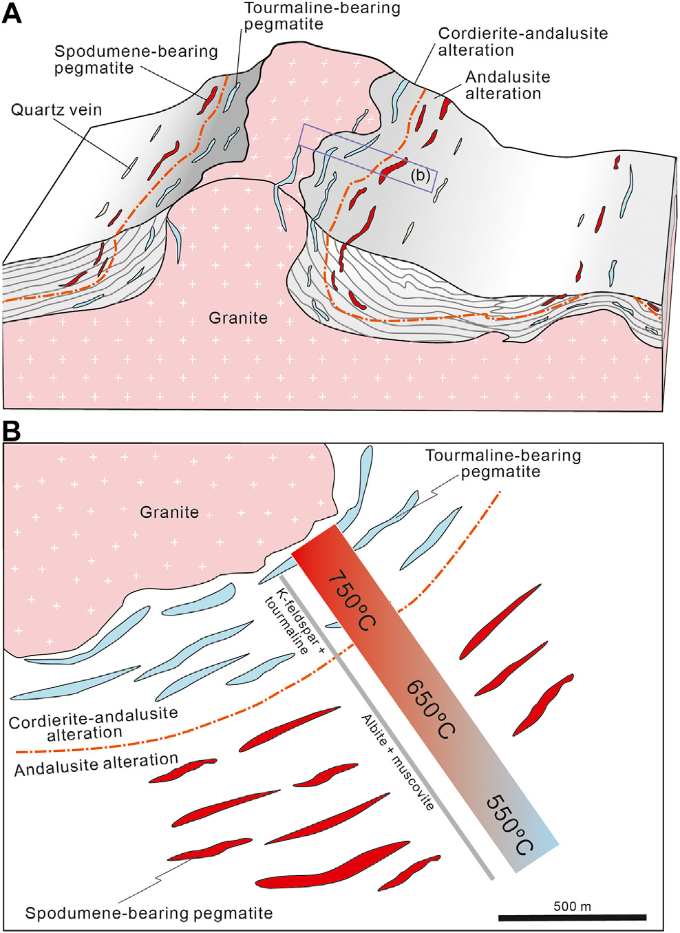
- FIGURE 9 | Model of pegmatite swarms in the Dahongliutan area (NW-China) (Gao et al. 2020), showing: (A) cross-section of the Triassic granite-pegmatite system; and (B) plan view of the pegmatite zonation. Host rocks are Late-Triassic deep-water turbiditic clastic sediments and minor carbonate rocks.
.
Excluding U.S. production (withheld), worldwide lithium production contained in mineral concentrates and brines in 2021 increased by 21% to approximately 100,000 tonnes from 82,500 tonnes in 2020 in response to strong demand from the lithium-ion battery market and increased prices of lithium (USGS 2022). Global consumption of lithium in 2021 is estimated to be 93,000 tonnes, a 33% remarkable increase from 70,000 tonnes in 2020.
In 2021, Australia dominated world output with ~55% of the total contained in spodumene, followed by Chile (~26% of world production), China (14%) and Argentina (6%), producing from natural brines. Global identified resources (~90 Mt) and reserves (22 Mt) are large. USGS data are given in metric tonnes of contained lithium unless otherwise noted. The media provide ample information on the rapidly growing need for lithium, because it is one of the key metals for new age green energy technologies, especially for electricity storage. Currently, global end-use markets are estimated to consume about 74% of world Li for batteries (USGS 2022).
For practicioners, the open-access paper by Scogings et al. 2016 is most valuable. It "examines lithium production markets and prices, reporting of exploration results, special considerations that should be applied to the reporting of pegmatite Mineral Resources and issues around Competence for the public reporting of lithium exploration results and resources." For example, ore for manufacturing heat-resistant glass, pyroceramics and enamels must be very low in impurities of Fe, Mn, Ti and Cr.
References
Álvarez-Amado F, Rosales M, Godfrey L, et al. (2022) The role of ignimbrites and fine sediments in the lithium distribution and isotopic fractionation in hyperarid environments: Insights from Li-isotopes in the Atacama Desert. J Geochemical Exploration 241:107062, ISSN 0375-6742. Https://doi.org/10.1016/j.gexplo.2022.107062.
Bowell RJ, Lagos L, de los Hoyos CR & Declercq J (2020) Classification and characteristics of natural lithium resources. Elements 16:259-264. Htpps: //doi.org/10.2138/gselements.16.4.259
Bradley, D.C., McCauley, A.D. & Stillings, L.M. (2017) Mineral-deposit model for lithium-cesium-tantalum pegmatites. U.S. Geological Survey Scientific Investigations Report 2010-5070-O, 48 pp. OPEN ACCESS https://doi.org/10.3133/sir20105070O.
Gao Y, Bagas L, Li K, Jin M, Liu Y & Teng J (2020) Triassic lithium deposits in the Dahongliutan Area, North-West China: A case study for the detection of lithium-bearing pegmatite deposits in rugged terrains using remote-sensing data and images. Front. Earth Sci. 8:591966. doi: 10.3389/feart.2020.591966 OPEN ACCESS
Pohl, WL (2020) Economic Geology, Principles and Practice: Metals, Minerals, Coal and Hydrocarbons - an Introduction to Formation and Sustainable Exploitation of Mineral Deposits. 2nd ed. 755 pp. Schweizerbart Science Publishers, Stuttgart. Print www.schweizerbart.de/9783510654352 (Soft Cover), www.schweizerbart.de/9783510654413 (Hard Cover). E-book (PDF) ISBN 9783510654369 sold by https://www.lehmanns.de/shop/naturwissenschaften/57770431-9783510654369-economic-geology
Scogings, A., Porter, R. & Jeffress, G. (2016) Reporting exploration results and mineral resources for lithium mineralised pegmatites. AIG Journal Paper N2016-001, 9 pp. Australian Institute of Geoscientists. OPEN ACCESS www.aigjournal.aig.org.au
USGS, United States Geological Survey (2022) USGS minerals information webpages. Annual mineral commodities summaries. Lithium 2022. https://www.usgs.gov/centers/national-minerals-information-center/commodity-statistics-and-information Accessed in August 2022.
back to top
Home
.
'Metallogeny' - My Open Access Review employing the case of GOLD for the study (Published 14 June 2022; Blog Update 25 July 2022)
Pohl, W.L. (2022) Metallogenic models as the key to successful exploration -- a review and trends. Mineral Economics (2022):36 pp. Springer. https://doi.org/10.1007/s13563-022-00325-3 Creative Commons Licence Open Access
How welcome is it to learn from the publisher's production team: "Congratulations. We're pleased to inform you that we've published your article and it's available to view online." 'Viewing' includes that the PDF can be downloaded. Readers of the article will also be able to use enhanced PDF features such as search and annotation tools, one-click supplements, citation file exports and article metrics. To this day (September 19, 2022), Springer Nature counts about 1400 accesses to this paper.
I have spent most of the year 2021 collecting published, and my own thoughts about metallogeny, and writing this review paper that should provide access to the present scientific essence of metallogeny and its application in exploration. It is confined to gold metallogeny, because this sector of the industry is of foremost economic importance. The review is based on numerous publications, most of the recent past, which reflect current global understanding of the term metallogeny and how it is employed. Older literature is less often cited, in order to avoid ending up with a full-scale book.
To this day, Springer Nature counts about 1000 accesses to this paper.A short definition of metallogeny goes like this, taken from the Abstract of my Review:
"Metallogeny is the science of ore and mineral deposit formation in geological space and time. Metallogeny is interdisciplinary by nature, comprising elements of natural science disciplines such as planetology to solid state physics and chemistry, and volcanology. It is the experimental forefront of research and bold thinking, based on an evergrowing foundation of solid knowledge. Therefore, metallogeny is not a closed system of knowledge but a fast-growing assemblage of structured and unstructured information in perpetual flux."
Metallogeny acompanied my professional life as an economic geologist from the beginning, initially nudged by my teacher and mentor Walter E. Petrascheck. I hope that my views (and the many examples referenced) might help to clarify the core concepts, systems, models, and metallogeny's place in current terminology and practice.
Here, I'll abstain from reporting details of the contents in the review, just read it. But allow me to highlight the 11 figures (with their subtitles) of this paper that have been put into a PDF file, which you will find under:
Supplementary Information (Annex) . The PDF and the online version contains a link that leads to the supplementary material (a PDF of 1913 KB) at
https:// doi. org/ 10. 1007/ s13563- 022- 00325-3
My favourite is Figure 5 (Mantle_Gold_Fertilization_Pohl.jpg) that shows novel concepts of process systems of gold metallogeny at active continental margins (Pohl 2022):
.

- Fig 5 Schematic sketch of major plate tectonic settings of gold metallogeny: Mid-oceanic Cu-Zn-Au-Ag mineralization (triangles) is being carried towards the metallogenic subduction factory underneath an active continental margin, where the slab is devolatized by low T/high P metamorphism. The mafic crust along the slab top surface is the main source of water released at subarc depths (Holt & Condit 2021). The eclogitized slab breaks and founders downwards. Metalliferous supercritical fluids and melts may metasomatize ('fertilize') the mantle wedge or subcontinental lithospheric mantle (SCLM). Enriched, or 'metasomatized' mantle (mSCM) is the source of hydrous and metalliferous magmas and fluids that rise toward the surface where they form porphyry, epithermal and orogenic gold ore deposits. The great mass of calc-alkaline magma builds the continental, or Cordilleran, volcanic arc. The back-arc basin may display bimodal alkaline igneous rocks, and IOCG (iron oxide copper gold) or gold-rich VMS (volcanic massive sulfide) deposits. An approaching plume can provide matter and heat, or even gold to this system, or may mobilize matter from older fertilized mantle.
.
Extract from the Conclusions
Science and practice of metallogeny ultimately serve to supply mineral raw materials that are needed for a dignified life of humankind. Earth has a much larger endowment of mineral resources than is often claimed. Proponents of impending 'limits to growth' have been proved wrong by scientific arguments (Wellmer and Scholz 2018, 2017), and indeed, by the mining industry that reliably satisfies global requirements. There is no reason to assume a shortage of raw materials, if the mining sector is allowed to do its work. This paper is a call for the appreciation of metallogeny as the holistic science of ore formation, and in that role, as a fundamental toolbox for exploration. The body of metallogenic knowledge grows at a quick pace. Like human ingeniousness, this growth is unlimited.
back to top
Home
The Metallogenesis of Orogenic Gold Deposits: A remarkable contribution from China (May 18, 2022) (OPEN ACCESS)
Once more, we are informed of a new metallogenic enlightenment derived by investigations targeting a gold deposit in the North China Craton (NCC: see earlier News items): The giant high-grade Dongping gold deposit with reserves of 120 t Au (Fan et al 2022).
The authors provide the following Abstract of their paper:
Lode gold deposits, which are currently the world's major gold supply, have been shown to be generated mostly by phase separation of metamorphic fluids and/or interaction between these fluids and wall rocks. Here we use garnet oxygen isotopes by secondary ion mass spectrometry to document the crucial role of magmatic hydrothermal fluids and their mixing with meteoric water in the formation of the world-class Dongping gold deposit in the North China Craton. Garnet grains from quartz veins of various paragenetic stages and the mineralized alteration envelope at Dongping have dynamic δ18O variations of 3.8 to 211 ‰, with large intragrain fluctuations up to 5.3 ‰. These values correspond to calculated δ18O values of 6 to 29 ‰ for the hydrothermal fluids from which the garnet formed. The isotope data, notably the cyclic alternation in δ18O within individual garnet grains, are best interpreted to reflect multiple pulses of magmatically derived fluids and mixing of each pulse with variable amounts of meteoric water. The results presented here allow us to quantify the significant interplay between magmatic hydrothermal fluids and meteoric water that spanned the entire mineralization history and triggered gold deposition of a lode gold deposit. This study highlights the potential use of in situ oxygen isotope analysis of garnet in tracing the origin and evolution of hydrothermal fluids in the Earth's crust that may have formed giant ore deposits.
Study the authors' explanatory figures:

- Fig 4. Schematic illustration showing the hydrothermal fluid system from which various minerals precipitated to form the Dongping gold deposit. (A) Magmatic fluid pulses were repeatedly exsolved from the underlying magma chamber. Faults and fractures facilitated ascension of magmatically derived fluids and higher up their mixing with meteoric water, causing gold deposition and associated veining. Disseminated mineralization in alteration envelopes occurred in less-fractured wall rocks where the infiltration of meteoric water was minor. Various mineral assemblages in pre- (S1), syn- (S2-a), and postore (S3) veins and the mineralized alteration envelopes (S2-b) formed in response to fluid mixing. (B) Evolution trend of δ18Owater values of garnet grains from each paragenetic stage indicating pulsed injection of magmatic fluids [red bar; δ18Owater = 5 to 10 ‰; (21, 22)] and incursions of meteoric water [blue bar; average δ18Owater = -12 ‰; (30, 31)]. The range and variations of oxygen isotopic ratios for each stage are defined using δ18Owater values shown in Fig. 3 and SI Appendix, Fig. S5. The brown and beige solid lines correspond to the brown and beige garnet grains, respectively (Fan et al 2022).
.
In the main text, the authors mention that earlier stable isotope investigations of bulk fluid inclusions in quartz at Dongping had already indicated that the average δ18O might reflect a mixture of magmatic and meteoric water. Their high-precision data confirm this but illuminate the wide range of mixtures. For comparison, you might look up other published δ18O values. In principle we know that part of the orogenic gold is magmatic-hydrothermal in origin (Pohl 2020) but this paper is first in providing hard analytical data.
Interesting are the authors' speculations that mixing and cooling of hot upflow by meteoric water precipitated gold and the gangue. Do you think this is valid?
Very useful is the concise description of 'Methods' at the end of the paper, with the headings: Sample Preparation. - SEM and EPMA. - Oxygen Isotope Analysis by SIMS. - Trace Element Analysis by LA-ICP-MS. - Calculation of δ18O Values of Garnet-Forming Aqueous Fluid. - Estimation of Meteoric Water Contribution.
In addition, this article contains voluminous supporting information online at https://www.pnas.org/doi/full/10.1073/pnas.2116380119#supplementary-materials
You did notice that the paper is OPEN ACCESS. The read is highly recommended, even if your quest is not oxygen isotopes, and you do not have all the fancy equipment anyway!
References
Fan G-H, Li J-W, Valley J-W, et al (2022) Garnet secondary ion mass spectrometry oxygen isotopes reveal crucial roles of pulsed magmatic fluid and its mixing with meteoric water in lode gold genesis. PNAS 119 (19) e2116380119 | https://doi.org/10.1073/pnas.2116380119 OPEN ACCESS
Pohl WL (2020) Economic Geology, Principles and Practice: Metals, Minerals, Coal and Hydrocarbons – an Introduction to Formation and Sustainable Exploitation of Mineral Deposits. 2nd ed. 755 pp. Schweizerbart Science Publishers, Stuttgart. ISBN 978-3-510-65435-2. eBook ISBN 9783510654369. www.schweizerbart.de/9783510654352
back to top
Home
The Essential Metallogenic Role of the Sub-Continental Lithospheric Mantle (SCLM) in Eastern China (March 28, 2022) OPEN ACCESS
In a recent open access paper, Yang et al (2022) describe and reconfirm the outstanding metallogenic role of the sub-continental lithospheric mantle (SCLM) based on data gathered in Eastern China. The importance of the SCLM as a source of ore metals has earlier been recognized by Griffin et al (2013) who wrote that "models for ore genesis and exploration need to incorporate the entire lithosphere to be effective" . The paper by Yang et al (2022) applies the principles of enriched SCLM sourcing metallogenic systems to the Precambrian North China and Yangtze cratons. Their main theme, however, is the preferred location of great ore deposits within a 100 km wide zone along the present margins of these cratons.
Read Yang et al's (2022) Abstract for the essential information
The current margins of the North China and Yangtze Cratons provide arguably the best examples globally of anomalously high mineral endowment within a 100 km buffer zone, hosting 66 diverse world-class to giant ore systems that help explain China's premier position as a producer of multiple metal and mineral commodities. After the cratonization of these crustal blocks during the Neoarchean-Paleoproterozoic, with incorporation of iron ores on assembled micro-block margins, the margins of the cratons experienced multiple convergence and rifting events leading to metasomatism and fertilization of their underlying sub-continental lithospheric mantle. The rifted margins with translithospheric faults provided pathways for Cu-Au (Mo-W-Sn)-bearing felsic to Ni-Cu-bearing ultrabasic intrusions and REE-rich carbonatite magmas, and for the development of marginal sedimentary basins with both Cu-Pb-Zn-rich source units and reactive carbonate or carbonaceous host rocks. There was diachronous formation of hydrothermal orogenic gold, antimony, and bismuth systems in the narrow orogenic belts between the cratons. Complexity in the Mesozoic Paleo-Pacific subduction systems resulted in asthenosphere upwelling and lithosphere extension and thinning in the North China Craton, leading to anomalous heat flow and formation of orogenic gold deposits, including those of the giant Jiaodong gold province on its north-eastern margin. These gold deposits, many of which formed from fluids liberated by devolatilization of previously metasomatized sub-continental lithospheric mantle, helped propel China to be the premier gold producer globally. The thick sub-continental lithospheric mantle of the cold buoyant cratons helped the preservation of some of the world's oldest porphyry-skarn and epithermal mineral systems. Although craton margins globally control the formation and preservation of a diverse range of mineral deposits, China represents the premier example in terms of metal endowment due to the anomalous length of its craton margins combined with their abnormally complex tectonic history.
End of Abstract
Yang et al (2022) mapped the distribution of 66 world-class to giant metal deposits (as defined by Singer 1995) located within ~100 km of these margins; the sites contain ore-grade concentrations of Ag, Au, Cu, Fe, Mo, Nb, Ni, Pb, REE, Sb, Sn, W, and/or Zn. Most are renowned mining districts such as Bayan Obo, Daqiao, Jiaodong, Jinding and Shizhuyuan (Pohl 2020). The Supplementary Data Table S1 provides summary information and key references for each of the 66 deposits. Salient features of the 17 largest and most diverse deposits are summarized in Table 1. Figure 1 provides an overview of the tectonic framework of Eastern China and the position of the 66 great metalliferous ore deposits mapped. Figure 2 is of outstanding interest, because it summarizes the tectonic, geodynamic and metallogenic history of the major components of the North China and Yangtze cratons, along a time axis from the formation of continental nuclei soon after 3.8 Ga to the present; this allows to check, which one of the giants were formed at times of supercontinent formation or breakup, of orogeny or rifting, and various phases of re-working. Episodic tectonic events from ~2.3 Ga to ~700 Ma produced translithospheric extensional and transpressional faults in marginal zones that increased local crustal permeability. The margins were further modified from 520 to 200 Ma by diachronous Paleozoic to Triassic orogenies related to subduction of the Proto-Tethys (Shangdan), paleo-Asian, and Paleo-Tethys (Mianlue) oceans. From ~240 to 130 Ma, the North China craton (NCC) margin experienced a unique period of 'decratonization' by the complex changes of the Jurassic to Cretaceous subduction geometry of the paleo-Pacific. Slab break-off and roll-back of the paleo-Pacific Plate induced delamination and thinning of the lithosphere in the NCC, inducing asthenospheris upwelling, increasing thermal gradients, widespread magmatism, and formation of the highly endowed Jiaodong Peninsula gold province at ~120 Ma (Figure 1; Yang et al 2022).
Strangely, the Neoarchean Wilson Cycle of the Trans-North orogen crossing the NCC described by Zhong Y et al (2021) (see my Blog below, dated December 15, 2021) is not referenced; apparently, some journals are quicker to publish than others ...

- Figure 1. Tectonic framework of Eastern China showing 66 world-class to giant mineral deposits within ~100 km of the margins of the North China and Yangtze cratons: compiled by Yang et al (2022). Abbreviations: OGD = orogenic gold deposits; OGD-JD = orogenic gold deposits-Jiaodong; ORG = orogenic Au-Sb deposits. Courtesy Yang et al (2022)
.
Yang et al (2022) describe the Jiaodong gold event in their Chapter 7 (here shortened and modified): Arguably, the most important metallogenic event in the NCC, at least in terms of gold mineralization, was related to the Upper-Jurassic to Lower Cretaceous sub-continental lithospheric mantle (SCLM) thinning and delamination due to the complex history and geometry of subduction related to convergence of the Paleo-Pacific Plate (Yang and Santosh 2020; see their Fig 2 in my blog below "GOLD * GOLD * GOLD * Remarkable Publications! April 12, 2021"). This resulted in asthenospheric upwelling, granitic magmatism, and mesozonal to epizonal orogenic gold mineralization at 120 Ma. The Jiaodong Gold Province contains >35% (>5000 t gold) of China's gold resource, in 17 giant orogenic deposits sited within 100 km of the margins of the NCC and YC. The auriferous ore fluids most likely had a non-crustal source. In terms of sub-crustal fertility, the significant older (>2000 my) pre-mineralization crustal metamorphism, combined with sulfur, lead and strontium isotope ratios that are inconsistent with crustal sources of these elements, indicate a dominant subcrustal source for the ore components of the Jiaodong gold deposits, consistent with evidence for volatile- and probable gold-fertilized metasomatized mantle lithosphere beneath at least part of the NCC. Helium-Ar and C-O isotope ratios also implicate mantle sources of ore fluids. For the Jiaodong gold province, the ore fluids are interpreted to have been derived from metasomatized SCLM on the NCC margin that was fertilized by volatiles and gold during earlier Triassic subduction of gold-enriched pyritic sedimentary rocks from the northern margin of the YC. In the Cretaceous, asthenospheric upwelling related to complex subduction of the Paleo-Pacific plate caused devolatilization of the metasomatized and fertilized SCLM to release auriferous ore fluids. These fluids advected via lithosphere-scale faults on the NCC margin and were focussed into subsidiary faults and shear zones to form the Jiaodong gold deposits. The deposits were preserved due to relatively slow exhumation despite the previous lithosphere delamination.
If you should be interested in details of one of the Jiaodong gold deposits, you may consult the recently published paper by Lan et al (2022).
References
Condie KC (2022) Chapter 4 - The mantle. Pp 81-125 in Earth as an Evolving Planetary System (4th ed Kent C. Condie) Academic Press, ISBN 9780128199145. DOI https://doi.org/10.1016/B978-0-12-819914-5.00010-X
Griffin WC, Begg GC & O'Reilly SY (2013) Continental-root control on the genesis of magmatic ore deposits. Nature Geoscience 6:905-910. DOI https://doi.org/10.1038/ngeo1954
Lan T, Fan Y, Lu J, et al (2022) Origin of the Dayingezhuang gold deposit in the Jiaodong district, eastern China: Insights from trace element character of pyrite and C-O-S isotope compositions. J of Geochemical Exploration 236:106986. ISSN 0375-6742. DOI https://doi.org/10.1016/j.gexplo.2022.106986
Pohl WL (2020) Economic Geology, Principles and Practice: Metals, Minerals, Coal and Hydrocarbons – an Introduction to Formation and Sustainable Exploitation of Mineral Deposits. 2nd ed. 755 pp. Schweizerbart Science Publishers, Stuttgart. ISBN 978-3-510-65435-2. eBook ISBN 9783510654369. www.schweizerbart.de/9783510654352
Singer DA (1995) World class base and precious metal deposits -- A quantitative analysis. Economic Geology Bull 90:88-104. 10.2113/gsecongeo.90.1.88
Yang LQ, Deng J, Groves DI, et al (2022) Metallogenic 'factories' and resultant highly anomalous mineral endowment on the craton margins of China. Geoscience Frontiers 13/2:101339. ISSN 1674-9871. https://doi.org/10.1016/j.gsf.2021.101339 Creative commons license Open Access
Zhong Y, Kusky Th, Wang L, et al (2021) Alpine-style nappes thrust over ancient North China continental margin demonstrate large Archean horizontal plate motions. Nature Communications 12:6172. DOI https://doi.org/10.1038/s41467-021-26474-7 Creative Commons Attribution 4.0 International License Open Access
back to top
Home
Late Archean Alpine-Style Full Wilson Cycle Plate Tectonics in Northern China (Open Access) (March 1st, 2022)
The emergence of modern plate tectonics is a long-standing open issue in Earth Science. A recent paper by Zhong Yating et al. (2021) reports detailed observations and data that constitute a solid proof of modern-style plate tectonics in the North China Craton. There, the authors demonstrate that modern plate tectonics was operating since about 2.7 Ga very much alike, for example, to the Mesozoic orogeny in the Eastern Alps of Central Europe.
Read the Authors' Abstract for the essentials: "Whether modern-style plate tectonics operated on early Earth is debated due to a paucity of definitive records of large-scale plate convergence, subduction, and collision in the Archean geological record. Archean Alpine-style sub-horizontal fold/thrust nappes in the Precambrian basement of China contain a Mariana-type subduction-initiation sequence of mid-ocean ridge basalt blocks in a 1600-kilometer-long mélange belt, overthrusting picritic-boninitic and island-arc tholeiite bearing nappes, in turn emplaced over a passive margin capping an ancient Archean continental fragment. Picrite-boninite and tholeiite units are 2698 ± 30 million years old marking the age of subduction initiation, with nappes emplaced over the passive margin at 2520 million years ago. Here, we show the life cycle of the subduction zone and ocean spanned circa 178 million years; conservative plate velocities of 2 centimeters per year yield a lateral transport distance of subducted oceanic crust of 3560 kilometers, providing direct positive evidence for horizontal plate tectonics in the Archean".
Of course, it remains unknown if the Central Orogenic Belt in the Neoarchean North China Craton ( Figure ) dates the absolutely earliest instance of Plate Tectonics on Earth, or if that has happened ages before.
- Schematic cross sections through the Central Orogenic Belt in the Neoarchean North China Craton (Credit: Zhong, YL. et al. Figs 10a and b)
Windley et al. (2021), for example, suggest that (1) 'Accretionary Cycle Plate Tectonics' of small protocontinents with short boundaries started from 4 Ga, followed by (2) 'Wilson Cycle Plate Tectonics' with its long plate boundaries beginning by about 2.7 Ga. Yet, accretion in front of drifting protocontinents with limited subduction is part of Bédard's (2018) lid tectonic model (find more in my News Archive January 05, 2018). By the way, Windley et al. (2021) dismiss lid tectonics and similar models of Archean Earth. The case remains undecided; is it a matter of terms only? My opinion gained from published literature is that lid tectonics did exist and gradually evolved into plate tectonics.
Metallogenic systems in terms of lid tectonics are sketched as follows (Bédard 2018): Within the basalt-komatiite units, thick BIF (Algoma type, or volcanogenic exhalative basalt-related banded iron formations) and chert sequences are intercalated. Komatiites (Arndt et al 2008) host orthomagmatic rivers of nickel sulfide in submarine lava channels or as disseminated bodies in subvolcanic intrusions (Barnes et al 2017). Archean volcanogenic polymetallic massive base metal-sulfide (VMS) deposits may have formed from fluids mobilized by reheating of the hydrated submarine volcanic pile, caused by new magma pulses. The deep sections of imbricated and accreted foreland terranes were the source of gold-carrying metamorphic fluids and magmas, resulting in orogenic Au deposits.
Metallogenic consequences include that (1) plate tectonic models may be fully trusted and employed in applications such as exploration from the Neoarchean (~2.8 Ga) until the present; (2) pushing back or abandoning lid tectonics totally relegates the potential of this hypothesis to lower ranks. Yet, I have the impression that Windley's et al. (2021) 'Accretionary Cycle Plate Tectonics' may not be very different from Bédard's (2018) large oceans of lid tectonics dotted by drifting protocontinents that accreted, eventually amalgamated and finally formed megacontinents. In the Late Archean, the stage was set for deep subduction of cool and dense oceanic crust, and for the plate tectonic metallogenic factories operating as we know them now.
References
Bédard, J.H. (2018) Stagnant lids and mantle overturns: implications for Archaean tectonics, magma genesis, crustal growth, mantle evolution, and the start of plate tectonics. Geoscience Frontiers 9, 19-49. Open Access https://doi.org/10.1016/j.gsf.2017.01.005
Windley, B.F., Kusky, T. & Polat, A. (2021) Onset of plate tectonics by the Eoarchean. Precambrian Res. 352, 105980 (2021). https://doi.org/10.1016/j.precamres.2020.105980
Zhong, Y., Kusky, Th., Wang, Lu, et al. (2021) Alpine-style nappes thrust over ancient North China continental margin demonstrate large Archean horizontal plate motions. Nature Communications 12:6172. Open Access Creative Commons Attribution 4.0 International License. https://doi.org/10.1038/s41467-021-26474-7
back to top
Home
Deep Crustal Magneto—Telluric Features of Giant Gold Fields in the Victorian Gold Province of SW Australia (Open Access) (October 30, 2021)
Metallogeny investigates the formation of ore deposits from source to trap. Much is known about the latter, but the source(s) of gold remain disputed and many different models are discussed; main opinion groups search the source (1) either in the crust or, (2) increasingly in current papers, in the mantle. For individual gold deposits, districts and provinces, the source of gold remains a recurring quest as metallogenic understanding is fast expanding.
A remarkable recent open access paper by Heinson et al. (2021) reports magneto-telluric data and interpretations from the Victorian gold province hosting the Bendigo and Ballarat fields, once fabulously rich gold producers in SW Australia. Historic gold production from all sources (eluvial, alluvial, paleoplacer and rock hosted lodes) is throught to have delivered ~2500 t of gold (Taylor et al. 2017b) and an equal mass may remain hidden beneath younger cover (Taylor et al. 2017a).
In non-genetic terms, Victorian gold is 'shale, or turbidite hosted'. In current common nomenclature it is of the'orogenic type'. I would prefer to call the deposits members of the 'metamorphogenic-hydrothermal clan' (Pohl 2020: p. 236).
Victorian gold deposits consist of quartz vein fields in anticlinoria, trapped along vertical fluid escape zones. Structural and lithological control of gold quartz veins are equally important. Early veins form an interconnected fracture mesh controlled by folds, bedding planes, cleavage and reverse faults and are partly deformed. Most gold mineralization was synchronous with peak compressional deformation and metamorphism but extended into late tensional strain. Muscovite 40Ar/39Ar geochronological data of auriferous veins at Ballarat reveal a duration of deformation and mineralization from 445 to 370 Ma. Fluids were reduced, CO2-rich, of low salinity and reached temperatures of 350 ± 25 degrees C. Ore paragenesis comprises free gold, pyrite, arsenopyrite and pyrrhotite in quartz with ankerite and albite. Host rock alteration is macroscopically visible because of proximal bleaching and a wide halo of siderite spots; microscopic features include the introduction of sericite, chlorite, carbonates and pyrite-arsenopyrite. High-grade ore shoots occur at the contact with pyritic and graphitic beds ("indicator beds") and lumps of native gold were found that reached 18.8 kg. Since 1851, Victoria State produced a total of 2500 t of gold, of which ~40% were derived from quartz veins. The larger part was extracted from placer deposits that included some famously rich bonanzas, especially in 'deep leads' (buried paleoriver courses). The heaviest nugget weighed 71 kg.
For an overview, read the Abstract of Heinson et al. (2021a)
"Orogenic gold deposits provide a significant source of the world's gold and form along faults over a wide range of crustal depths spanning sub-greenschist to granulite grade facies, but the source depths of the gold remains poorly understood. In this paper we compiled thirty years of long-period magnetotelluric (MT) and geomagnetic depth sounding (GDS) data across western Victoria and south-eastern South Australia that have sensitivity to the electrical resistivity of the crust and mantle, which in turn depend on past thermal and fluid processes. This region contains one of the world's foremost and largest Phanerozoic (440 Ma) orogenic gold provinces that has produced 2% of historic worldwide gold production. Three-dimensional inversion of the long-period MT and GDS data shows a remarkable correlation between orogenic gold deposits withâ over âone tonne of total gold production and aâ less than 20 Ωm low-resistivity region at crustal depthsâof more than 20 km. This low-resistivity region is consistent with seismically-imaged tectonically thickened marine sediments in the Lachlan Orogen that contain organic carbon (C), sulphides such as pyrite (FeS2) and colloidal gold (Au). Additional heat sources at 440 Ma due to slab break-off after subduction have been suggested to rapidly increase the temperature of the marine sediments at mid to lower crustal depth releasing HS- ligands for Au, and CO2. We argue that the low electrical resistivity signature of the lower crust we see today is from a combination of flake graphite produced in situ from the amphibolite grade metamorphism of organic carbon in the marine sediments, and precipitated graphite through retrograde hydration reactions of CO2 released during the rapid heating of the sediments. Thus, these geophysical data image a fossil source and pathway zone for one of the world's richest orogenic gold provinces."

- Fig 2 (c) from Heinson et al. 2021. Resistivity depth slice near the lithosphere-asthenosphere boundary (~ 150 km). Black circles are long-period MT and GDS observation sites used in the three-dimensional inversion; blue circles are broadband MT transects that were not used in the inversion. Large yellow circles represent gold mines with total production of more than one tonne; smaller white circles show production less than one ton Au. Solid black lines represent the boundaries of major tectonic elements, and the white lines show coastlines and bathymetry contours at 1000 m depth intervals. The colour scale bar on the right side represents resistivity values within the range of 10 to 10,000 Ωm.
The tectonic setting of the Victorian Gold Province was a subduction related active margin of Gondwana. Heinson's et al. (2021a) results appear to demonstrate that the Bendigo-Ballarat low-resistivity anomaly extends down to the boundary between the sub-continental lithospheric mantle (SCLM) and the asthenosphere (their Figure 2C above), although at values about 100 Ωm. The authors attribute the very low values of less than 32 Ωm of crust below the Bendigo-Ballarat zone to flake graphite in the rocks, which would be absent in the lithosphere. They refrain from any interpretation, however, and solely report that a heat anomaly caused by slab break-off and intrusion of hot asthenosphere may have acted on the crust (Vos et al. 2007). In one of the slides, Heinson (2021b) showed an arrow from below marked 'plume' but did not comment on it. Of course, there are now a number of potential explanations how heat, or fluids or melts (with or without gold) may impact the SCLM from below and cause or contribute to ore formation.
Is it likely that these magneto-telluric (MT) data may assist exploration? My quick answer is 'not directly'. But in the case of the Victorian Gold Province, the results reported by Heinson definitely refine the metallogenic model and generally, better models lead to improved exploration. Would you agree or reject this conclusion?
Yet, generally, deep imaging of crust and mantle by MT is an extremely promising exploration tool, especially for cases of buried hydrous or otherwise conductive sources, such as metasomatized subcontinental lithospheric mantle (SCLM). If the Victorian gold would have been buried similar to giant Olympic Dam IOCG (below 400 m cover), Heinson et al. (2021) might have reported a giant propicious anomaly.
References
Heinson, G., Duan, J., Kirkby, A. et al. (2021a) Lower crustal resistivity signature of an orogenic gold system. Nature Sci Rep 11, 15807 (2021). https://doi.org/10.1038/s41598-021-94531-8 Open Access (license http://creativecommons.org/licenses/by/4.0/).
Heinson, G. (2021b) Lower crustal resistivity signature of an orogenic gold system. Ore Deposits Hub October 20, 2021. Public YouTube Recording link: https://youtu.be/u3GZfsyF9so
Pohl W.L. (2020) Economic Geology, Principles and Practice: Metals, Minerals, Coal and Hydrocarbons – an Introduction to Formation and Sustainable Exploitation of Mineral Deposits. 2nd ed. 755 pp. 32 Colour Plates, 305 Figures, 32 Tables, 25 Boxes, 81 Equations. Schweizerbart Science Publishers, Stuttgart.(Soft Cover)
Taylor, D.H., Willman, C.E., Hughes, M.J. & Boucher, R.K. (2017a) Recent gold mining and exploration in Victoria. Pp 807-810 in Australian Ore Deposits (ed G.N. Phillips), Australasian Institute of Mining and Metallurgy.
Vos, I.M.A., Bierlein, F.P. & Heithersay, P.S. (2007) A crucial role for slab break-off in the generation of major mineral deposits: insights from central and eastern Australia. Miner. Deposita 42, 515-522. https://doi. org/ 10.1007/s00126- 007- 0137-3
back to top
Home
Delamination – Induced HT – Metamorphism and A–Type Magmatism in the Eastern Kunlun Belt, China (September 15, 2021)
Most economic geologists will be aware of the metallogenetic role of granites and granitoids, and that their source is a strong control on possibly related mineralization. Investigation by petrological and geochemical methods allows determination of their origin by melting of three major 'source' components, which include (1) Peridotites of the Earth's upper mantle (asthenosphere, metasomatized lithosphere); (2) Intermediate volcanic or intrusive magmatic and metamorphic rocks of the deep continental crust (infracrustal); and (3) Clastic sediments and metamorphic equivalents (supracrustal).
Mainly mantle-derived (1) are A-type, or ferroan granitoids. They are characterized by iron–rich mafic mineralogy, ferroan, alkali–calcic to alkaline affinities, high LILE + HFSE abundances, typically by exsolving OH–F bearing fluids and crystallizating under reduced or oxidized conditions (Bonin 2007). A-type granites are formed under alkali–rich, anhydrous, and anorogenic conditions by melting of source rocks under low–pressure and high–temperature conditions (Frost & Frost 2019). They occur within plates and at distensive plate boundaries. They are often exposed at a subvolcanic level in ring complexes together with mafic igneous rocks. The origin of A–type granites was originally sought in extreme differentiation of basaltic melt; currently, derivation from lower crustal or lithospheric mantle sources is considered more common (Bonin 2007). A–type granites occur mainly in the Early to Middle Mesoproterozoic, a period that is marked not only by A–type granites, but also by anorthosites and by the absence of arc magmatism, subduction indicators, passive margins and seafloor spreading that characterize modern plate tectonics.
Different ore associations occur with A–type granitoids (Pohl 2020): i) Sodium–rich granites, striking because of attached albitite bodies, are related to concentrations of niobium, uranium, thorium, rare earth elements and some tin; and ii) potassium–rich granites with profuse hydrothermal silicification, tourmalinization and acidity produce deposits of molybdenum, tin, tungsten, lead, zinc and fluorspar. The second association may occur within the granite body (endogranitic greisen, pegmatite, and porphyry stockwork ore) or as vein fields in country rocks (exogranitic). A–type granites genetically related to magmatic–hydrothermal iron oxide–copper–gold (IOCG) deposits constitute a third economically important variety (Mueller & Groves 2019, Skirrow et al. 2019).
A–type granites are the alkali granites of continental rifts, for example the Jurassic W–Sn granites of the Nanling metallogenetic province in China or the Mesoproterozoic rapakivi granites in Finland with their large red perthitic alkali feldspars mantled by green plagioclase in a fine-grained groundmass. A suite of distinct post–collisional hornblendite, gabbro, granite and mafic granulite (ferroan granitoids?) was identified in the eastern Kunlun Orogen in China (Wang et al. 2022). This 3000–km–long W–E striking mountain belt formed by closure of the Proto–Tethys ocean that dated from the breakup of the Rodinia Supercontinent and by Late Paleozoic collision of Gondwana and Siberia. The authors provide petrological data such as zircon U–Pb geochronology, zircon in situ Hf isotope, mineral and whole–rock geochemistry, and whole–rock Sr–Nd isotope compositions. Strangely, Wang et al. (2022) fail to identify A–type granites in the text (and omit any reference to related mineralization), but in one of the figures (see below) they provide a geodynamic model sketch of the post–collisional extensional phase in the Late Devonian, when lithospheric delamination and upwelling of asthenosphere caused heating, deep metamorphism, partial melting and intrusion of S–type granites and A–type granitoids. This model may be useful as input into future research on the origin of A–type granitoids and their metallogeny.

- Sketch showing post–collisional hornblendite, gabbro, S–type granite and A–type granitoid intrusions identified in the eastern Kunlun Orogen in China, caused by delamination and upflow of asthenosphere (Wang et al. 2022)
.
A quick search for an English language description of the Kunlun metallogeny was not successful. Maybe you have more luck?
References
Bonin, B. (2007) A–type granites and related rocks: Evolution of a concept, problems and prospects. Lithos 97, 1–29.
Frost, B.R. & Frost C.D. (2019) Essentials of Igneous and Metamorphic Petrology. 2nd ed. 362 pp. ISBN 978-1-108-71058-9. Cambridge University Press.
Mueller, D. & Groves, D.I. (2019) Potassic igneous rocks and associated copper–gold mineralization. 5th ed. 398 pp. Mineral Resource Reviews. Springer.
Pohl W.L. (2020) Economic Geology, Principles and Practice: Metals, Minerals, Coal and Hydrocarbons – an Introduction to Formation and Sustainable Exploitation of Mineral Deposits. 2nd ed. 755 pp. Schweizerbart Science Publishers, Stuttgart. ISBN 978-3-510-65435-2. www.schweizerbart.de/9783510654352
Skirrow, R.G., Murr, J., Schofield, A., et al. (2019) Mapping iron oxide Cu–Au (IOCG) mineral potential in Australia using a knowledge–driven mineral systems–based approach. Ore Geology Reviews 113, 103011. OPEN ACCESS https://doi.org/10.1016/j.oregeorev.2019.103011
Wang, Q., Zhao, J., Zhang, Ch., et al. (2022) Paleozoic post–collisional magmatism and high–temperature granulite–facies metamorphism coupling with lithospheric delamination of the East Kunlun Orogenic Belt, NW China. Geoscience Frontiers 13, 101271, ISSN 1674-9871. https://doi.org/10.1016/j.gsf.2021.101271 OPEN ACCESS
back to top
Home
Brian McNulty's Book Review of my Economic Geology 2nd ed (Pohl 2020) (August 06, 2021)

- Cover_pohl_economic_geology_2020
.
Brian McNulty is Postdoctoral Researcher in Economic Geology at the University of Nevada, Las Vegas, with a Ph.D. from the University of Tasmania — CODES, Australia (2019). Find a link to his professional profile below, if you are interested; it is certainly remarkable how it took him across the globe.
Brian wrote this review for the Society of Economic Geology (SEG) Bulletin, where it appeared first online a few days ago (citation below). SEG has about 10,000 members across the world. I am a member of this Society for more than two decades; so I asked them to arrange a review. In quality, the SEG Bulletin is arguably the globally leading journal in Economic Geology.
Brian's review of my book is remarkable, one of the best I have ever seen. I don't mean that he lauds my Economic Geology, which he does, but his text of two pages is an excellent description that adresses all questions, which anyone might wish to have answered in a book review. I'll cite a couple of paragraphs:
"I thoroughly enjoyed the applied aspect of this textbook, specifically "Part III: The Practice of Economic Geology." We all have our own origin story and, for some of us, this geology adventure has led us to lifelong careers as explorers, resource modelers, engineers, or environmental scientists. The life cycle of natural resources from discovery, beneficiation, and through to remediation is wonderfully presented in this section and highlights the numerous areas of expertise that encompass the multidisciplinary field of economic geology. Pohl captures the essence of economic geology so eloquently with the following text":
"Never forget that exploration is not only a scientific and technical enterprise but foremost an investment" (p. 447)
Brian also writes: "The format of the book, which includes informative yet condensed chapters with ample suggested readings, makes for a great choice of textbook for undergraduate and postgraduate students, as well as an excellent addition to the libraries of professional geoscientists interested in understanding and applying aspects of economic geology to their field of interest."
"Overall, I appreciate the different ways this book could be utilized by students, various academic researchers, and industry professionals. The book is a valuable resource in introducing the geologic processes involved in metal, nonmetal, and fossil fuel formation, including explanatory petrogenetic and tectonic deposit models, as well as how to apply this knowledge to exploration. The book also summarizes the current understanding of metals, elements, and minerals on an individual basis and does not shy away from the fact that society, industry, and academia need to work together to provide solutions toward sustainable natural resource management."
Thank you for your efforts, Brian!
References
Brian McNulty Professional Profile https://geoscience.unlv.edu/post-doctoral-researchers/brian-a-mcnulty/
McNulty, B.A. (2021) BOOK REVIEW Walter L. Pohl: Economic Geology, Principles and Practice: Metals, Minerals, Coal and Hydrocarbons — Introduction to Formation and Sustainable Exploitation of Mineral Deposits (2nd revised edition): Schweizerbart Science Publishers, Stuttgart, 2020, hard-cover (ISBN 978-3-510-65441-3; price Euro 94.00), soft cover (ISBN 978-3-510-65435-2; price Euro 79.00) and ebook (ISBN 978-3-510-65436-9). Economic Geology (2021) 116 (6): 1485-1486. ISSN 0361-0128; doi:10.5382/econgeo.116.6.br02
back to top
Home
Anthropocene Revisited — Biologists Foresee a Managable Future for the Entire Planetary Ecosystem. Open access paper (July 20, 2021)
Economic Geology strives to supply human societies with needed Earth materials. Geologists assist in discovery and exploitation of ores and minerals, and in controlling damage to stakeholders and the environment. If you are interested in the great frame of our work, the well-being of humanity and our planet, you may be interested to read this paper by Lehman et al. (2021).
The main content of the paper concerns population dynamics of hominins. Introductory remarks concerning the Anthropocene and geologists are somewhat perfunctory such as "...prompting geologists to begin applying the term Anthropocene to recognize the present moment" (Abstract see below). Are we concerned with moments? In fact, although accepted by the Working Group of the IUGS Stratigraphic Commission, the term has not yet been formally accepted (http://quaternary.stratigraphy.org/working-groups/anthropocene/).

- Planet Earth. Courtesy European Space Agency (ESA) https://www.esa.int/
.
The paper by Lehman et al. 2021 being OPEN ACCESS, you may skip the rest of this blog and go online to read it fully. For the others, here are some excerpts:
Abstract: Human populations have grown to such an extent that our species has become a dominant force on the planet, prompting geologists to begin applying the term Anthropocene to recognize the present moment. Many approaches seek to explain the past and future of human population growth, in the form of narratives and models. Some of the most influential models have parameters that cannot be precisely known but are estimated by expert opinion. Here we apply a unified model of ecology to provide a macroscale summary of the net effects of many microscale processes, using a minimal set of parameters that can be known. Our models match estimates of historic and prehistoric global human population numbers and provide predictions that correspond to some of the more complicated current models. In addition to fitting the data well they reveal that, amidst enormous complexity in our human and prehuman past, three key ecological discontinuities have occurred in turn: 1) becoming dominant competitors of large predators rather than their prey, 2) becoming mutualists with food species rather than acting as predators upon them, and 3) changing from a regime of uncontrolled population growth to one of controlled fertility instead. All three processes have been interlinked with cultural evolution and all three ushered in developments of the Anthropocene. Understanding the trajectories that have delivered us to this stage can help guide prudent paths into the future.
The Possibilist Agenda
Considering what is possible, and cutting on a separate plane across the range of attitudes from cynicism to pessimism to optimism to Pollyannaism, is "possibilism". In approaching self-inflicted problems of global scale, and also much more local problems, possibilism recognizes that the course of human events largely is not the domain of probability. Probability derives from combinations of many connected steps beyond our influence or knowledge. In human events, outcomes often depend on only a few major steps, often not beyond our influence or knowledge.
Therefore, in following the possibilist agenda, one first evaluates and eliminates what is impossibleâwhat cannot occur by the laws of the universe. What remains is the tentatively possible, including both the desirable and the undesirable. Following the possibilist agenda means working tirelessly to imagine both possibilities and impossibilities and then laying plans to arrange events so that the desirable can be realized and the undesirable avoided — working to avoid unintended consequences. In this way, by superposing such thoughts onto recognized physical–biological–social problems of the world, including those described above, seemingly intractable problems may have possibilist solutions.
Directions Forward
Accompanying our domination and disruption of the planet has begun a conscious awareness of the magnitude of our powers to help guide us to prudent paths into the future. Ours is the first species to become aware of our global scope, the first to organize global communication and satellite monitoring of the planet as a whole, and the first consciously to consider how to create a sustainable planet.
We now face our next daunting challenge — learning to manage our role on the planet for our continued existence and — we can hope and expect — for that of our fellow creatures. Will our modern existence be a minor blip on the geological timescale, as indicated by the suffix " -cene" in " Anthropocene" ? Or will we be able — as a geologist suggested a century ago — to elevate our existence to the dignity of an era and advance the Anthropocene into the Anthropozoic?
There is reason for hope. It may seem unimaginable that we can learn to manage consciously the entire planetary ecosystem. We should, however, remember that throughout our relatively short history, the unimaginable repeatedly has morphed into the commonplace.
Reference
Lehman, Cl., Loberg, Sh., Wilson, M., Gorham, E. (2021) Ecology of the Anthropocene signals hope for consciously managing the planetary ecosystem. Proceedings of the National Academy of Sciences 118 (28) e2024150118; DOI: 10.1073/pnas.2024150118 OPEN ACCESS
back to top
Home
Book Review 4 of my Economic Geology 2nd ed (June 15, 2021)
CITATION OF THE BOOK REVIEW: Frank Melcher (2021) Walter L. Pohl: Economic Geology, Principles and Practice: Metals, Minerals, Coal and Hydrocarbons - Introduction to Formation and Sustainable Exploitation of Mineral Deposits (2nd revised edition): Schweizerbart Science Publishers, Stuttgart, 2020, hard-cover (ISBN 978-3-510-65441-3; price Euro 94.00), soft cover (ISBN 978-3-510-65435-2; price Euro 79.00) and ebook (ISBN 978-3-510-65436-9). Mineralogy and Petrology. 10.1007/s00710-021-00754-y. OPEN ACCESS
- Cover_pohl_economic_geology_2020
.
Prof. Frank Melcher is Full Professor of Economic Geology at the Montanuniversität Leoben in Austria. He is an excellent teacher and scientist. I know him for remarkable papers on Columbite (Ta) deposits in Africa. The last publication in this series is:
Wouters, S., Hulsbosch, N., Kaskes, P., Claeys, P., Dewaele, S., Melcher, F., Onuk, P. & Muchez, P. (2020) Late orogenic gold mineralization in the western domain of the Karagwe-Ankole Belt (Central Africa): Auriferous quartz veins from the Byumba deposit (Rwanda). Ore Geology Reviews 125, 19 pp., 103666.
You may find more about Prof Melcher and his research at https://pure.unileoben.ac.at/portal/en/persons/frank-melcher
In his review of my EG2, Prof. Melcher characterizes my book by ... "Economic geology is the application of geoscience to the supply of metals, minerals, and energy to society. The subject plays a central role in the exploration, evaluation, and development of deposits as well as in the mining and processing of raw materials. Economic geology is an indispensable discipline that is needed to meet mankind's increasing demand for nonrenewable raw materials and to further develop our society. In this expanded edition, Pohl is able to include current topics and crosslink them with future problems in the raw material supply. Thus, aspects of sustainable "green" mining, conservation of nature and the environment, and consequences for climate change are addressed within an ethical framework ..."
Melcher goes on with ... "Economic Geology, Principles and Practice is divided into four comprehensive Parts. In the first, the deposits of the metals are dealt with over 300 pages. In keeping with previous editions, the processes leading to the accumulation of metals in the Earth's crust and mantle ("metallogenesis") are treated first, and are described in detail and with the most up-to-date sources. Important subchapters are dedicated to the investigation methods for hydrothermal deposits as well as an outline of metallogenesis in the course of the Earth's history. This is followed by a chapter that is subdivided by the individual metallic raw materials, which are organized under the subheadings: iron and steel metals, nonferrous metals, precious metals, light metals as well as minor metals and speciality metals (including uranium and thorium), including many of the so-called critical raw materials. These individual chapters contain a veritable flood of interdisciplinary information and are a treasure trove for students, professors, professional geologists, and mineral enthusiasts. All relevant areas are represented including: mineralogy and geochemistry, deposit types and classification (numerous current examples), economic aspects, and notes on mining and processing ..."
The last chapter summarizes the two pages by ..."localities index, which helps in the targeted search for the about 1000 deposits and locations referenced in the EG2. The work is of an astonishing breadth and comprehensiveness. Basic knowledge of geology and mineralogy as well as some technical knowledge will make it easier for beginners to get started with this book. But with prior knowledge, it will captivate anyone interested in raw materials. This is a wonderful reference textbook that you will find yourself rereading again and again, whether to study a chapter in more detail, to look something up, or simply to learn something new. I highly recommend it to all mining geologists, reservoir geologists, and applied geoscientists ...."
Thank you, Frank, for your time in writing the review. Dear Reader, note that the book review is OPEN ACCESS (see above). One additional comment — the e-book version of my Economic Geology should soon be available. It will display all figures in colour.
back to top
Home
A Heap of Gold — the Tiny Volcanic Island and Giant Lihir (Ladolam) Deposit of Papua New Guinea (May 18, 2021)
If you are interested in Plate Tectonics, Volcanic Island Arcs, Mantle hydration and fertilization, and extraordinary gold deposits, this is for you. If this is not your thing, forgive me. Nowadays, I am writing a paper on gold metallogeny and cannot help being fascinated and sharing this with you!

- Figure 1 -- Newcrest's Lihir gold mine in PNG, sited in the caldera of Luise volcano (Courtesy itNews 2017) URL https://www.newcrest.com/our-assets/lihir
.
The supergiant LIHIR (OR LADOLAM) alkalic epithermal, magmatic-hydrothermal gold deposit was discovered by rock chip exploration in 1982, locating auriferous alunite (Cooke et al. 2020). In 2019, total resources were estimated to 690 Mt at 2.3 g/t Au, equivalent to 50 Moz in situ gold. Ore bodies occur on the floor of a large volcanic amphitheater in Luise volcano, a Pleistocene stratovolcano built of shoshonitic volatile-rich, silica-undersaturated, and highly oxidized igneous rocks (Cooke et al. 2020) comprising alkaline lavas and tuffs of trachybasalt, basaltic trachyandesite and latite. The deposit is unique for the overprinting of epithermal gold mineralization over earlier porphyry-style veins and altered rocks with abundant anhydrite and carbonate but low-grade Au. The transition was probably caused by the collapse of a sector of Luise volcano into the sea (Sillitoe 1994). In an extensional setting from 0.6 Ma onwards, the mineralization changed to epithermal-style with sulfide and adularia alteration, during which the main resource was emplaced. High-T geothermal activity is ongoing and the recovered energy is used in the mine.
Epithermal activity produced at least six discrete mineralized zones, and each of these is dominated by refractory gold in arsenian pyrite. Gold is associated with adularia-pyrite-carbonate-anhydrite ± illite alteration assemblages, cemented breccias, and veins that overprinted the early porphyry-style features. Bonanza gold grades are associated with late-stage quartz and/or anhydrite veins.
.

- Figure 2 -- Schematic cross-section through the present-day New Ireland Basin (from SW to NE) in the Lihir area (upper plate only). This block model is to illustrate the links between collision, microplate interaction, tectonic structure, regional magmatism and the focusing of melts and fluids. Tectonics control the regional metal endowment (melting of a metasomatized lithospheric mantle source described by McInnes et al. 2001) but local structure is responsible for the focusing of metalliferous liquids and fluids into an ore-forming system. Note Solvara-1 in the Southwest, a high-grade massive sulfide (SMS) seafloor mining prospect of copper, gold, zinc and silver that was abandoned in 2019. Courtesy Brandl et al. (2020).
.
Lihir lies in a broad, complex deformation zone caused by convergence of the Pacific and the Australian plate. The geodynamic setting is described as both postcollisional and back arc by Cooke et al. (2020). Brandl et al. (2020) place it into a former forearc followed by displacement to its current location in a rear- or backarc setting relative to active subduction along the New Britain Trench. The zone broke into microcontinents when colliding with the Ontong Java Plateau (OJP). Protracted, transtensional motion between distinct crustal blocks controls the location and timing of magmatism and mineralization (Figure 2).
Allow me to comment: One crucial point is missing in all this — the energy source. Energy is needed to initiate melting of the fertile mantle. Without energy, 2 billion years may pass by without ore formation. Look at the Jiaodong story in the blog before this one.
References
Brandl, Ph.A., Hannington, M.D., Geersen, J., et al. (2020) The submarine tectono-magmatic framework of Cu-Au endowment in the Tabar-to-Feni island chain, PNG. Ore Geology Reviews 121, 103491. ISSN 0169-1368. OPEN ACCESS. https://doi.org/10.1016/j.oregeorev.2020.103491
Cooke, D.R., Sykora, St., Lawlis, E., et al. (2020) Lihir alkalic epithermal gold deposit, Papua New Guinea. Pp. 579–597 in Geology of the World's Major Gold Deposits and Provinces (eds Sillitoe, R.H., Goldfarb, R.J., Robert, F. & Simmons, S.F.), SEG Special Publications 23, Society of Economic Geologists. Doi: 10.5382/SP.23.28.
McInnes, B.I.A., Gregoire, M., Binns, R.A., et al. (2001) Hydrous metasomatism of oceanic sub-arc mantle, Lihir, Papua New Guinea: petrology and geochemistry of fluid-metasomatised mantle wedge xenoliths. Earth Planet. Sci. Lett. 188, 169–183.
Sillitoe, R.H. (1994) Erosion and collapse of volcanoes: causes of telescoping in intrusion-centered ore deposits. Geology 22, 945-948.
back to top
Home
GOLD * GOLD * GOLD * Remarkable Publications! (April 12, 2021)
If you work in the gold sector, you should acquire the following recent publications (references below). You need them in order to be up to date and for future reference at your work place. They are singular!
The first is the multi-authored SEG volume 'Geology of the World's Major Gold Deposits and Provinces', edited by Richard H. Sillitoe, Richard J. Goldfarb, F. Robert, and Stuart F. Simmons (2020a). The book packs 895 pages, numerous tables, coloured maps and sections, and provides descriptions of 29 of the world's largest gold deposits or districts, and of 7 overviews of great gold provinces including terrane-scale geologic parameters and their controls on the localization, styles, and timing of gold mineralization. Each description summarizes exploration history and regional and local geologic settings preparatory to synthesizing the salient lithologic, structural, alteration, and mineralization features of the deposit itself.
An Epilogue contains a paper on epithermal, Carlin and orogenic gold deposition — a must for mine geologists.
In the Foreword to the book, Mark Bristow Ph.D., the President and Chief Executive of Barrick Gold Corporation, who sponsored the publication, writes:
This special volume gives geology its deserved due and provides a timely insight into the world's major gold deposits and provinces. It will be a highly valuable, long-lasting reference for all geoscience practitioners of this and future generations. I (WLP) would add that SEG Special Publication 23 will also serve as a useful source for academic teaching and research libraries.
My second recommendation concerns the Introduction to the SEG-volume by Sillitoe (2020b) that provides a thumbnail sketch of each important gold deposit type, including geologic and economic characteristics and widely accepted genetic models, as well as briefly discussing aspects of their spatial and temporal associations and distributions. Currently, ore deposits are often differentiated as types that are haphazardly named, not following a logical system. Deposit types of gold, for example, in order of decreasing endowment and overall economic importance, comprise:
Paleoplacer, orogenic, porphyry, epithermal, Carlin, geologically young placer, reduced intrusion related, volcanogenic massive sulfide (VMS), skarn, carbonate replacement, and iron oxide-copper-gold (IOCG) (Sillitoe 2020b). Although in many respects alike to typical orogenic gold, the giant Jiaodong province deviates in some features and is by some considered as a new 'Jiaodong gold depost type' (Qiu et al. 2020). It has a premining gold resource exceeding 4,500 metric tonnes (t). Jiaodong is a rare case where relatively young gold ores (ca. 120 Ma) were formed in terranes that are billions of years older (ca. 2.9— 1.9 Ga). Host rocks are Mesozoic granitoids. Orebodies are mainly quartz-pyrite veins, veinlets and disseminated mineralization, controlled by complex faults. Pinkish K-feldspar alteration forms an outer halo to the quartz-pyrite-sericite inner alteration halo that is intimately associated with gold ore. Jiaodong gold metallogeny occurred within a broad period of transition from a circum-Pacific oblique compressional to an extensional tectonic regime between ca. 160 and 90 Ma (Qiu et al. 2020).

- One possible solution for the plate tectonic setting of major Mesozoic gold deposit formation in the North China Craton; the Jiaodong province shown on right hand side. Note the gold source in metasomatized 'churning' mantle below (red dots). Courtesy Yang & Santosh 2020.
.
The SEG volume is not cheap but worth the expense. For those of you who find the cost too high I add below an open access source offering a different view about the possible new Jiaodong gold deposit type (Yang & Santosh 2020).
References
Qiu, K.-F., Goldfarb, R.J., Deng, J., et al. (2020) Gold Deposits of the Jiaodong Peninsula, Eastern China. Pp. 753— 773 in Geology of the World's Major Gold Deposits and Provinces (eds Sillitoe, R.H., Goldfarb, R.J., Robert, F., Simmons, S.F.), Spec. Publication 23, Society of Economic Geologists (SEG). Doi: 10.5382/SP.23.35.
Sillitoe, R.H., Goldfarb, R.J., Robert, F., Simmons, S.F. (eds) (2020a) Geology of the World's Major Gold Deposits and Provinces. Spec. Publication 23, 1-859 pp. Society of Economic Geologists (SEG).
Sillitoe, R.H. (2020b) Gold Deposit Types: An Overview. Pp. 1— 28 in Geology of the World's Major Gold Deposits and Provinces (eds Sillitoe, R.H., Goldfarb, R.J., Robert, F., Simmons, S.F.), Spec. Publication 23, Society of Economic Geologists (SEG). doi: 10.5382/SP.23.01.
Yang, Ch.-X. & Santosh, M. (2020) Ancient deep roots for Mesozoic world-class gold deposits in the north China craton: An integrated genetic perspective. Geoscience Frontiers 11, 203— 214. doi: 10.1016/j.gsf.2019.03.002. OPEN ACCESS under CC BY-NCND license (http://creativecommons.org/licenses/by-nc-nd/4.0/).
Back to top
Home
Safe Tailings Facilities? What are the Challenges? How to Approach Zero Risk? (March 20, 2021)
Tailings facility failures may endanger human lives, property, water resources, and the environment. They make great media news that shame the whole mining industry. This must end!
If you agree and if you are one of the many professionals who work in mining or in a mining-related job, in practice or in research, a suite of 25 papers that recently appeared in Mine Water and the Environment, the Journal of the International Mine Water Association (IMWA), is a great source of valuable technical information. The whole issue seems to be OPEN ACCESS. I was able to download some papers but I could not find an affirmative information. So just try. If this should not work, join the Association. The annual membership fees are very moderate.

- Mine Water and the Environment, the Journal of the International Mine Water Association (IMWA), Volume 40, issue 1. Tailings Storage: Challenges & Technologies, 25 articles in this issue. ?OPEN ACCESS??
.
In the Introduction, Fernández & Kleinmann (eds) (2021) conclude their short presentation of each of the 25 high class papers in the issue by warning words:
However, many challenges remain, including
- * the essential need not to increase the number of tailings storage facilities that use upstream dam construction (which is already a legal requirement in many countries) and the need to carefully investigate old storage facilities that have been built using this technology;
- * reducing the pore pressure in stored tailings through adequate drainage to prevent liquefaction processes;
- * the priority of storage with minimal water in the tailings, either by thickening or by filtration;
- * the convenience of storing tailings properly in mining voids; and
- * the need to continue to improve monitoring and warning systems for tailings dams and their surroundings. This applies to the varied geotechnical aspects, but especially the hydrological ones that are often neglected because they are approached by technicians from other disciplines without the knowledge of the complexities that water brings to these installations.
Rubio mentions the term 'upstream dam construction'. This is explained by the figure below, which is taken from a hydrogeological article in this issue (Morton 2021).

- Three construction variants of sequentially raised tailings dams or Tailings Storage Facilities (Morton 2021); note that the upstream variant has morphed toward continuous (not stepped) raising operation. In my Economic Geology you may find a photograph and explanation of this method (Pohl 2020 page 485 Fig. 5.19).
.
So how to approach zero risk? Let's act!
References
Fernández Rubio & Kleinmann, B. (eds) (2021a) Mine Water and the Environment Journal of the International Mine Water Association (IMWA), Volume 40, issue 1. Tailings Storage: Challenges & Technologies, 25 articles in this issue. ?OPEN ACCESS??
Fernández Rubio & Kleinmann, B. (2021b) Introduction to Special Issue on Tailings Storage: Challenges and Technologies. Mine Water Environ 40, 1–5. https://doi.org/10.1007/s10230-021-00757-3
Morton, K.L. (2021) The Use of Accurate Pore Pressure Monitoring for Risk Reduction in Tailings Dams. Mine Water Environ 40, 42-49 (2021). https://doi.org/10.1007/s10230-020-00736-0
Pohl W.L. (2020) Economic Geology, Principles and Practice: Metals, Minerals, Coal and Hydrocarbons — an Introduction to Formation and Sustainable Exploitation of Mineral Deposits. 2nd ed. 755 pp. Schweizerbart Science Publishers, Stuttgart.
back to top
Home
Newly Ordered ARCHIVED NEWS on my Website for Ease of Access and for Finding Links to Topics. Go to https://www.walter-pohl.com/news_archive.html (March 15 2021)
NEXT Book Review of Economic Geology 2nd ed. by Walter L. Pohl: Written by Dr. Richard H. Sillitoe (February 15, 2021)
- Cover_pohl_economic_geology_2020
Pohl, W.L. (2020) Economic Geology, Principles and Practice: Metals, Minerals, Coal and Hydrocarbons – an Introduction to Formation and Sustainable Exploitation of Mineral Deposits. 2nd ed. 755 pp. Schweizerbart Science Publishers, Stuttgart.
Dearly I would like to acquaint you with the whole of Richard's review, which is a paradigm of an informed, informative and useful critique, but copyright rules do not permit this. Accordingly, I cite here the last paragraph:
Economic Geology, Principles and Practice has something to offer to diverse audiences. It provides a useful introduction to the subject for senior undergraduates not only in economic geology but also in mining engineering, metallurgy, environmental studies and related fields. Graduate students and earlycareer professionals could dip into the volume for up-to-date introductions to topics beyond their specialist fields, and —if this reviewer is representative —even seasoned practitioners will surely find something new and of interest. The book is also strongly recommended to policy-makers, government officials, NGOs and the investment community needing a balanced overview of economic geology and the pivotal role it will play in the 'greening' of the world economy.
You do know that Dr. Sillitoe is one of the truly great economic geologists of our time?
Sillitoe, R.H. (2021) Walter L. Pohl: Economic geology, principles and practice: metals, minerals, coal and hydrocarbons — an introduction to formation and sustainable exploitation of mineral deposits (2nd ed.). Mineralium Deposita 56:619–620. https://doi.org/10.1007/s00126-021-01043-6
Back to top
Home
Gold Assay Methods — Precise and Accurate for Reporting to Stock Exchanges? (February 10, 2021)
Public companies, the shares of which are traded on stockmarkets are obligated to report regularly on progress in their operations. Any figures stated (grade, core intersections, resources) must be of highest quality. This is central to issues that are regulated by codes such J0RC (2012) in Australia.
Analytical data in exploration geochemistry need not in all cases be equal to the absolute element content in a sample, or in other words, accuracy may not be essential. Deviations from the absolute content (e.g. an international laboratory standard) may be tolerated, if the relative error remains within narrow limits. Accuracy is assessed by employing certified reference materials (standards). In contrast, excellent reproducibility of results from duplicates, that is high precision, is absolutely required. Precision is the base for any data evaluation, especially if the contrast between background and anomalies is small. In all analytical programmes error control (in practice called QAQC — quality assurance and quality control) is a fundamental aspect. Errors may be introduced during sampling, sample processing and transport, and in the laboratory. Always, samples should be randomized before submission to the laboratory in order to avoid analysing them in the same sequence as collected. Also, it is good practice to repeat at least 10% of sampling. Analytical errors are revealed by repeatedly inserting duplicates, blanks or a standard of known composition such as international reference materials into the series. Control by another laboratory is advisable. Based on this kind of data, it is possible to calculate total error margins and the confidence interval.
If you are working for a gold miner, you know that getting precise and accurate data for gold tenors in ore (Figure 1) or in prospecting samples is not easy. Ore grades are low (ppm) and ppb may be required in exploration. Gold-specific problems often arise during sampling and analysis because of three points (Pohl 2020):
- 1 In ore, gold is nearly always irregularly distributed (the nugget effect) and clustering may cause an apparent nugget effect;
- 2 because of the metal's softness and ductility, homogeneous comminution of gold particles is difficult; and
- 3 gold is much heavier than silicate gangue resulting in rapid gravity separation, e.g. in sample bags during transport.

- Figure 1 — Gold-Quartz-Sulfide Ore, Fairbanks, Alaska
In every individual project it is extremely important to experiment and work out a procedure that minimizes resulting errors. For gold, time-tested fire assays and INAA (Instrumental Neutron Activation Analysis) are analytical standard methods. A newly adapted gamma-activation analysis (developed by CSIRO, Australia, and marketed by Chrysos since 2016) provides equal precision and accuracy, and accepts samples weighing several hundred grams, which avoids errors induced by subsampling. Meanwhile, Chrysos TM Photon Assay has been chosen by many mines across gold producers globally. Durance et al. (2014) wrote that
the majority of pXRF studies are conducted by private industry and are regarded as proprietary; it appears that the same applies today to Chrysos Photon Assay.

- Figure 2 — ChrysosTM Photon Assay is applicable for commercial analytical laboratories and for mine site use; this image shows sample containers on the conveyor belt feeding the analyzer. Courtesy © Chrysos https://www.chrysos.com.au/
The paper by Durance et al. (2014) provides an exemplary investigation of pitfalls in using a novel analytical tool, in their case of pXRF (portable X-ray fluorescence spectroscopy). They stress the importance to regard the rules of choosing a matched matrix, and of not analysing samples and standards through paper packets, as is often done instead of XRF-suitable film, impairing the precision and accuracy of pXRF data obtained; generally, the pXRF signal is attenuated by the paper. Also, the authors propose a best practice approach that corrects pXRF data using factors obtained from laboratory-based analysis (such as XRF or ICP-MS) of representative samples derived from the same project area so that they are matrix- and concentration-matched.

- Figure 3 — Olympus VantaTM portable X-Ray Fluorescence analyser https://www.olympus-global.com/
The project area was a former gold mine East of Kalgoorlie in Western Australia. About 900 samples were pulverised (to 90% passing 75 mm). Moisture content of samples for pXRF analysis should not exceed 20%. Standards employed were fresh, oxidised, mafic and felsic lithologies that were originally designated for JORC-compliant QAQC reporting for high-and low-grade gold detection by bulk fire assay and ICP-MS analytical methods. Two National Institute of Standards & Technology (NIST) soil standards and a silica blank were supplied with the pXRF unit. Note that many standards are not certified for all elements, which are produced by pXRF; these " results " may be useless and not acceptable for JORC-compliant QAQC reporting.
The authors demonstrate such pitfalls and conclude: Portable XRF undoubtedly provides a rapid and cost-effective means of assessing geochemical changes down-hole and in the field, but the technique generates data containing uncertainties that need to be identified and removed prior to any detailed field or analytical campaign.
References
Chrysos (2021) Chrysos Photon Assay. URL https://www.chrysos.com.au/ Accessed February 2021.
CSIRO (2021) Commonwealth Scientific and Industrial Research Organisation. URL https://www.csiro.au/ Accessed February 2021.
Durance, P., Jowitt, S.M. & Bush, K. (2014) An assessment of portable X-ray fluorescence spectroscopy in mineral exploration, Kurnalpi Terrane, Eastern Goldfields Superterrane, Western Australia. Applied Earth Science 123:3, 150-163. doi.org/10.1179/1743275814Y.0000000052
JORC (2012) Australasian Code for Reporting of Exploration Results, Mineral Resources and Ore Reserves (The JORC Code). Available from
Pohl, W.L. (2020) Economic Geology, Principles and Practice: Metals, Minerals, Coal and Hydrocarbons — an Introduction to Formation and Sustainable Exploitation of Mineral Deposits. 2nd ed. 755 pp. Schweizerbart Science Publishers, Stuttgart. Citing from section 2.3.1 Gold (pages 224 — 240); 5.2.4 Geochemical Exploration (454 — 460). https://www.schweizerbart.de/9783510654352 (Soft Cover)
Back to top
Home
A Diamond for your Loved One? As Proof for Deep Down-Cycling of Carbon into Earth? (January 6th, 2021)
How about an extremely rare diamond as a small gift? Although this is virtual, it stands for one of the numerous geoscientific discoveries of recent years. The majority of common diamonds (type I) formed at the boundary of lithosphere and astenosphere of the Earth (at 150-240 km depth), but this one shown in Figure 1, belonging to rare blue boron-bearing (type IIb) diamonds, came from the lower mantle (more than 660 km deep).

- Figure 1 — A high quality 25.5 carat blue diamond recovered at Cullinan S.A. in April 2013. Credit: Petra Diamonds Limited
Smith et al. 2018 analysed trace minerals trapped in Clippir and in 46 samples of blue diamonds across the globe, and from this worked out that the gemstones must have formed in the lower mantle. This is confirmed by inclusions of bridgmanite (MgSiO3), the high-pressure form of olivine (called bridgmanite) in the deep mantle. Clippir crystallised from a melt made of Fe-Ni-C-S, the blue diamonds from boron-bearing fluids. Seawater-serpentinized oceanic crust and lithosphere are suggested to be the source of boron.
Both diamond types are some of the deepest ever found. Moreover, they reveal a pathway that extends from the oceanic crust at Earth's surface to the lower mantle, and a potential route for the ultra-deep cycling of carbon and water in our planet.
In an OreDepositHub talk in July 2020, Evan Smith showed a sketch of oceanic slab subduction and sinking, which provides this pathway (Figure 2). This is one branch of Carbon downcycling into the Earth, whereas volcanism is the largest source of Carbon upcycling from inner Earth into the atmosphere. Clippir, and the blue diamonds can be lifted upwards by mantle plumes that impinge on the subcontinental lithospheric mantle (SCLM) where they may be haphazardly mixed into kimberlite melts that erupt through mantle and crust, possibly forming diamondiferous pipes.

- Figure 2 — Subduction of oceanic slab sinking into the lower mantle provides volatiles and matter that form type IIa Clippir and IIb boron diamonds. Upwelling can lift the deep diamonds to the base of continental lithosphere where they may mix into nascent diamondiferous kimberlite melt (Evan Smith ODH029 2020).
Ore Deposits Hub at oredepositshub.com was founded because of Covid-restrictions to scientific exchange and is sponsored by the professional economic geology societies SGA, SEG, & IAGOD in order to provide Open Science Talks. If you register you may profit from the services they offer. Take the chance to meet fellow scientists!
And how can we fit this into the Petrogenetic-Tectonic Classification of ore deposit formation, which I am promoting? — Well, the petrogenesis of these diamonds is metamorphism passing into anatexis. Considering the high pressures at these depths, I suggest that they crystallised from a supercritical hydrous melt (page 131) also called a supercritical fluid/melt phase (as described by Thomas & Davidson 2016) on pages 35-36 in my Economic Geology 2nd ed. (Pohl 2020). Note that generally in present-day geoscience, the existence of this kind of phase is sadly disregarded. The tectonic setting may be called subduction and down-sinking of oceanic slabs.
References
Pohl, W.L. (2020) Economic Geology, Principles and Practice. 2nd ed. 755 pp. Schweizerbart Science Publishers, Stuttgart.
Smith, Evan (2020) How the biggest and best diamonds defy exploration. Gemmological Institute of America. Ore Deposits Hub (Youtube video ODH029) July 15 2020.
Smith, E.M., Shirey, St.B., Richardson, St.H., et al. (2018) Blue boron-bearing diamonds from the Earth's lower mantle. Nature 560, 84—87. doi: 10.1038/d41586-018-05830-6
Thomas, R. & Davidson, P. (2016) Revisiting complete miscibility between silicate melts and hydrous fluids, and the extreme enrichment of some elements in the supercritical state — Consequences for the formation of pegmatites and ore deposits. Ore Geol. Rev. 72, 1088-1101.
Back to top
Home